Why in news?
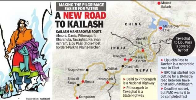
India, on May 8th, inaugurated an 80 km road goes right up to the Lipu Lekh pass on the LAC, through which Kailash Mansarovar pilgrims exit India into China to reach the mountain and lake revered as the abode of Siva.
Nepal protested and has also pointed out that it has brought up its concerns on the border issue several times, including in November 2019, when Delhi put out its new political map of India to show the bifurcation of Jammu-Kashmir.

Usefulness of the road
- The road is on the route of the annual Kailash Masarovar Yatra, which goes through Uttarakhand’s Pithoragath district.
- The road is built by the Border Roads Organisation (BRO)and is important for “strategic, religious and trade” reasons.
- What used to be a difficult trek for the pilgrims to the gateway, situtated at 17,060 ft, would now be an easy road trip.
- The new road is also expected to provide better connectivity to Indian traders for the India-China border trade at the Lipu Lekh pass between June and September every summer.
Complications around building the road
- Building roads leading to the contested LAC with China has been a fraught exercise for the government.
- It was only in the wake of the 70-day Doklam stand-off with China in 2017, that India realised with shock that most of those roads had remained on the drawing board.
- A report submitted by a standing committee flags the India China Border Roads (ICBRs) as a crucial element in “effective border management, security and development of infrastructure in inaccessible areas adjoining the China Border”.
Nepal’s Objection
- Army Chief General said on May 15th that Nepal’s protest was at “someone else’s behest”.
- His statement has been widely taken to mean that Nepal was acting as a proxy for China.
- Kathmandu has pointed out that it has brought up its concerns on the border issue several times, including in November 2019, when Delhi put out its new political map of India to show the bifurcation of Jammu & Kashmir.
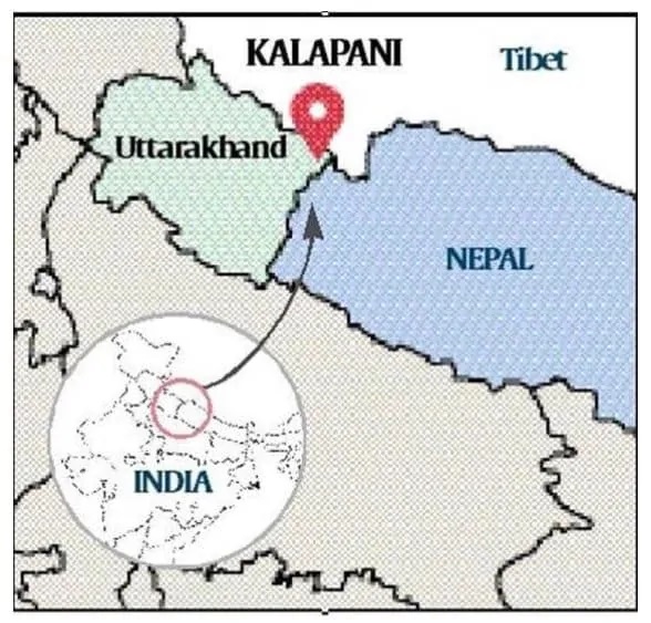
- Nepal’s objection then was the inclusion of Kalapani in the map, in which it is shown as part of Uttarakhand. The Kalapani area falls in the trijunction between India, China and Nepal.
- The Nepal government described India’s decision as “unilateral” and claimed that it would “defend its international border”, while the Ministry of External Affairs then said that map “accurately reflects the sovereign territory of India”.
Resolving Nepal-India Border issues
- The Nepal-India border was delineated by the Sugauli Treaty of 1816, under which it renounced all territory to the west of the river Kali, also known as the Mahakali or the Sarada river. The river effectively became the boundary.
- In the 1980s, the two sides set up the Joint Technical Level Boundary Working Group to delineate the boundary, which demarcated everything except Kalapani and the other problem area in Susta.
- In 2000, both sides agreed to demarcate the outstanding areas by 2002, which has not happened yet.
The Kalapani Issue Explained

- Nepal’s case is that the river originates from a stream at Limpiyadhura, north-west of Lipu Lekh. Thus Kalapani, and Limpiyadhura, and Lipu Lekh, fall to the east of the river and are part of Nepal’s Far West province in the district of Dharchula.
- New Delhi’s position is that the Kali originates in springs well below the pass, and that while the Treaty does not demarcate the area north of these springs, administrative and revenue records going back to the nineteenth century show that Kalapani was on the Indian side, and counted as part of Pithoragarh district, now in Uttarakhand.
China’s Role
- Since the 1962 war with China, India has deployed the ITBP at Kalapani, which is advantageously located at a height of over 20,000 ft and serves as an observation post for that area.
- Nepal calls it an encroachment by the Indian security forces.
- Nepal has also been unhappy about the China-India trading post at Lipu Lekh, the earliest to be established between the two countries.
- A year later, during the Doklam crisis, a senior official in the Chinese Foreign Ministry raised temperatures by suggesting that India would not be able to do anything if the PLA decided to walk in “through Kalapani or into Kashmir, through PoK”, both trijunctions like Doklam.
- Though China has said nothing about the road construction to Lipu Lekh, it has protested similar road building activity at other places on the Indian side close to the LAC, including Ladakh.
Conclusion
In view of all this, Kalapani and the approach to Lipu Lekh has only grown in strategic importance for India, especially as relations between the two countries have remained uneven over the last few years, and China has upped its game for influence in India’a neighbourhood.
-Source: Indian Express


