Static Quiz 31 March 2022
Quiz-summary
0 of 5 questions completed
Questions:
- 1
- 2
- 3
- 4
- 5
Information
Static Quiz 31 March 2022 for UPSC Prelims
You have already completed the quiz before. Hence you can not start it again.
Quiz is loading...
You must sign in or sign up to start the quiz.
You have to finish following quiz, to start this quiz:
Results
0 of 5 questions answered correctly
Your time:
Time has elapsed
You have reached 0 of 0 points, (0)
Categories
- Not categorized 0%
- 1
- 2
- 3
- 4
- 5
- Answered
- Review
- Question 1 of 5
1. Question
Which of the following statements about Karst Landforms are correct?
1. Karst is a landscape which is underlain by limestone which has been eroded by dissolution, producing towers, fissures, sinkholes, etc.
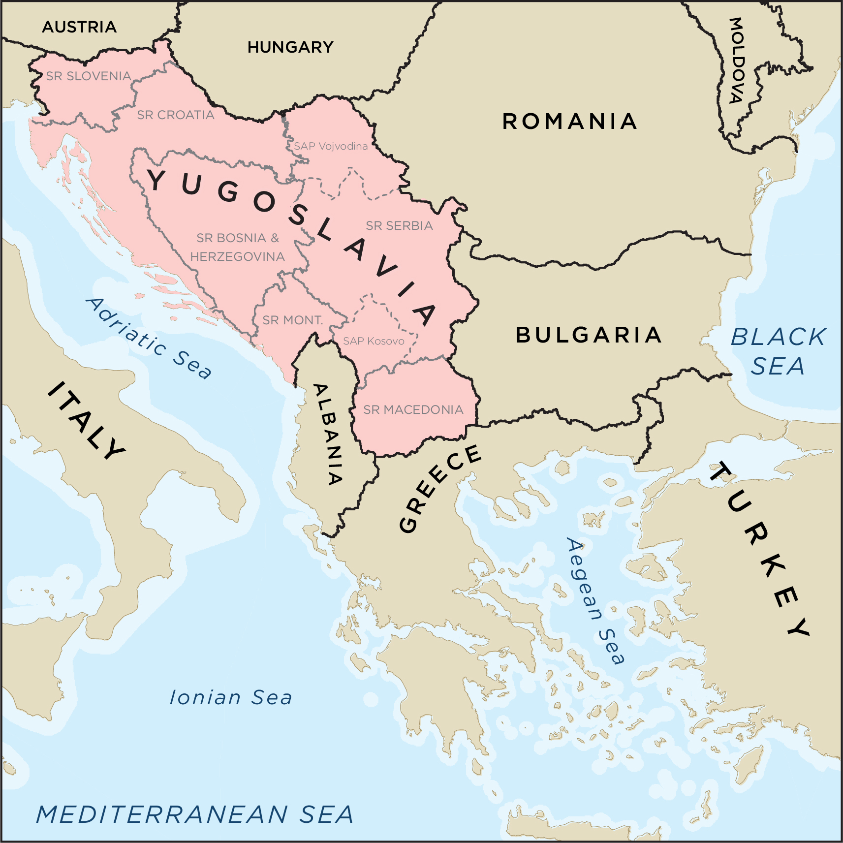
2. It is so named after a province of Yugoslavia on the black sea coast where such formations are most noticeable.CorrectAns;- a) Only 1
Explanation;-
• The 2nd statement is incorrect because it is on Adriatic Sea
About Karst Landforms
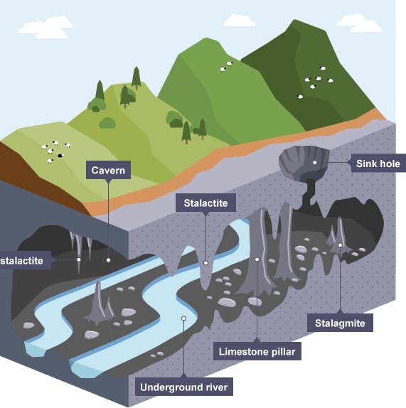
• Karst is a topography formed from the dissolution of soluble rocks such as limestone, dolomite, and gypsum.
• It is characterized by underground drainage systems with sinkholes and caves.
• Karst is a landscape which is underlain by limestone which has been eroded by dissolution, producing towers, fissures, sinkholes, etc.
• It is so named after a province of Yugoslavia on the Adriatic sea coast where such formations are most noticeable.
• Karst topography is a landscape formed from the dissolution of soluble rocks such as limestone, dolomite, and gypsum.
• It is characterized by underground drainage systems with sinkholes, caves etc..
• Presence of soluble rocks, preferably limestone at the surface or sub-surface level.
• These rocks should be dense, highly jointed and thinly bedded.
• Presence of soluble rocks, preferably limestone at the surface or sub-surface level.
• These rocks should be dense, highly jointed and thinly bedded. Incorrect
Ans;- a) Only 1
Explanation;-
• The 2nd statement is incorrect because it is on Adriatic Sea
About Karst Landforms
• Karst is a topography formed from the dissolution of soluble rocks such as limestone, dolomite, and gypsum.
• It is characterized by underground drainage systems with sinkholes and caves.
• Karst is a landscape which is underlain by limestone which has been eroded by dissolution, producing towers, fissures, sinkholes, etc.
• It is so named after a province of Yugoslavia on the Adriatic sea coast where such formations are most noticeable.
• Karst topography is a landscape formed from the dissolution of soluble rocks such as limestone, dolomite, and gypsum.
• It is characterized by underground drainage systems with sinkholes, caves etc..
• Presence of soluble rocks, preferably limestone at the surface or sub-surface level.
• These rocks should be dense, highly jointed and thinly bedded.
• Presence of soluble rocks, preferably limestone at the surface or sub-surface level.
• These rocks should be dense, highly jointed and thinly bedded.
- Question 2 of 5
2. Question
Which of the following statements are correctly matched?
1. Stalagmite = is an icicle-shaped formation that hangs from the ceiling of a cave and is produced by precipitation of minerals from water dripping through the cave ceiling.
2. Stalactite = is an upward-growing mound of mineral deposits that have precipitated from water dripping onto the floor of a cave.CorrectAns;- d) None of the above
Explanation;-
• Both the are incorrectly matched because both are reversed.
• A stalagmite is an upward-growing mound of mineral deposits that have precipitated from water dripping onto the floor of a cave. Most stalagmites have rounded or flattened tips. There are many other types of mineral formations found in caves.
• A stalactite is an icicle-shaped formation that hangs from the ceiling of a cave and is produced by precipitation of minerals from water dripping through the cave ceiling. Incorrect
Ans;- d) None of the above
Explanation;-
• Both the are incorrectly matched because both are reversed.
• A stalagmite is an upward-growing mound of mineral deposits that have precipitated from water dripping onto the floor of a cave. Most stalagmites have rounded or flattened tips. There are many other types of mineral formations found in caves.
• A stalactite is an icicle-shaped formation that hangs from the ceiling of a cave and is produced by precipitation of minerals from water dripping through the cave ceiling.
- Question 3 of 5
3. Question
Which of the following are the Conditions Essential for Full Development of Karst Topography ?
1. Presence of soluble rocks, preferably limestone at the surface or sub-surface level.
2. These rocks should be dense, highly loose and thinly bedded.CorrectAns;- a) Only 1
Explanation;-
• The 2nd statement is incorrect because These rocks should be dense, highly jointed and thinly bedded, not highly loose.
Conditions Essential for Full Development of Karst Topography
a. Presence of soluble rocks, preferably limestone at the surface or sub-surface level.
b. These rocks should be dense, highly jointed and thinly bedded.
c. Relatively thick massive soluble rock, i.e., limestone, dolomite, or chalk.
d. Carbonate rocks should be very close to the ground surface.
e. Lime stones should not be porous.
f. Limestone should be highly folded, faulted or fractured.
g. Marked development of joints. If the rock is bedded, the beds should be thin.
h. Considerable relief so that water is capable of circulation to cause typical karst topography.
i. Moderate to heavy rainfall to cause solution of rocks.IncorrectAns;- a) Only 1
Explanation;-
• The 2nd statement is incorrect because These rocks should be dense, highly jointed and thinly bedded, not highly loose.
Conditions Essential for Full Development of Karst Topography
a. Presence of soluble rocks, preferably limestone at the surface or sub-surface level.
b. These rocks should be dense, highly jointed and thinly bedded.
c. Relatively thick massive soluble rock, i.e., limestone, dolomite, or chalk.
d. Carbonate rocks should be very close to the ground surface.
e. Lime stones should not be porous.
f. Limestone should be highly folded, faulted or fractured.
g. Marked development of joints. If the rock is bedded, the beds should be thin.
h. Considerable relief so that water is capable of circulation to cause typical karst topography.
i. Moderate to heavy rainfall to cause solution of rocks. - Question 4 of 5
4. Question
Which of the following are the importance of Karst Topography?
1. Caves are large enough survival of animals, forest dwellers.
2. The karstified limestone acts as aquifers it contain huge amount of water, which can used during dry months.CorrectAns;- c) Both 1 and 2
Explanation;-
• Both the statements are correct.
Importance of Karst topography
• Karst is a special type of landscape that is formed by the dissolution of soluble rocks, including limestone and dolomite. Karst regions contain aquifers that are capable of providing large supplies of water. More than 25 percent of the world’s population either lives on or obtains its water from karst aquifers.
• Caves are large enough survival of animals, forest dwellers.
• The karstified limestone acts as aquifers it contain huge amount of water, which can used during dry months.
• Example: Two million people in central Texas get their drinking water from the karst aquifer known as the Edwards Aquifer.
• Caves, sinkholes, underground streams karst landforms can be spectacular and support unique ecosystems, which is why they need protection.
• New South Wales (NSW) karst environments are among the oldest and most complex in the world, giving them outstanding national and international importance.IncorrectAns;- c) Both 1 and 2
Explanation;-
• Both the statements are correct.
Importance of Karst topography
• Karst is a special type of landscape that is formed by the dissolution of soluble rocks, including limestone and dolomite. Karst regions contain aquifers that are capable of providing large supplies of water. More than 25 percent of the world’s population either lives on or obtains its water from karst aquifers.
• Caves are large enough survival of animals, forest dwellers.
• The karstified limestone acts as aquifers it contain huge amount of water, which can used during dry months.
• Example: Two million people in central Texas get their drinking water from the karst aquifer known as the Edwards Aquifer.
• Caves, sinkholes, underground streams karst landforms can be spectacular and support unique ecosystems, which is why they need protection.
• New South Wales (NSW) karst environments are among the oldest and most complex in the world, giving them outstanding national and international importance. - Question 5 of 5
5. Question
Which of the following are the Erosional Arid Landforms?
1. Ravine
2. Badland Topography
3. RillCorrectAns;- d) All of the above
Explanation;-
• All are erosional arid landforms
Erosional Arid Landforms
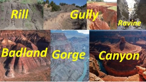
• Rill
In hill slope geomorphology, a rill is a narrow and shallow channel cut into soil by the erosive action of flowing water.
• Gully
A gully is a landform created by running water. Gullies resemble large ditches or small valleys, but are metres to tens of metres in depth and width.
• Ravine
A ravine is a landform narrower than a canyon and is often the product of stream cutting erosion. Ravines are typically classified as larger in scale than gullies, although smaller than valleys.
• Badland Topography
In arid regions occasional rainstorms produce numerous rills and channels which extensively erode weak sedimentary formations.
Ravines and gullies are developed by linear fluvial erosion leading to the formation of badland topography.
Example: Chambal Ravines. Incorrect
Ans;- d) All of the above
Explanation;-
• All are erosional arid landforms
Erosional Arid Landforms
• Rill
In hill slope geomorphology, a rill is a narrow and shallow channel cut into soil by the erosive action of flowing water.
• Gully
A gully is a landform created by running water. Gullies resemble large ditches or small valleys, but are metres to tens of metres in depth and width.
• Ravine
A ravine is a landform narrower than a canyon and is often the product of stream cutting erosion. Ravines are typically classified as larger in scale than gullies, although smaller than valleys.
• Badland Topography
In arid regions occasional rainstorms produce numerous rills and channels which extensively erode weak sedimentary formations.
Ravines and gullies are developed by linear fluvial erosion leading to the formation of badland topography.
Example: Chambal Ravines.


