Static Quiz 27 March 2023
Quiz-summary
0 of 5 questions completed
Questions:
- 1
- 2
- 3
- 4
- 5
Information
Static Quiz 27 March 2023 for UPSC Prelims
You have already completed the quiz before. Hence you can not start it again.
Quiz is loading...
You must sign in or sign up to start the quiz.
You have to finish following quiz, to start this quiz:
Results
0 of 5 questions answered correctly
Your time:
Time has elapsed
You have reached 0 of 0 points, (0)
Categories
- Not categorized 0%
- 1
- 2
- 3
- 4
- 5
- Answered
- Review
- Question 1 of 5
1. Question
Arrange the Lakes of Ladakh from north to south?
1. Tso Moriri
2. Tso Kar
3. Pangong LakeCorrectAns;- c) 3-2-1
Explanation;-
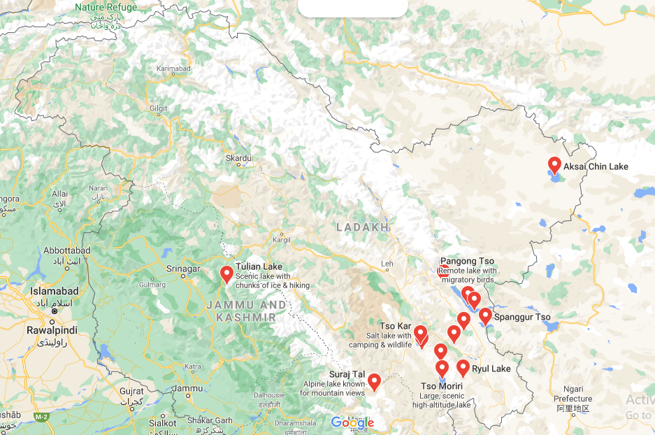
• The lakes of Ladakh from north top south as shown in the below attached image.

• Pangong Tso lake is in the process of being identified under the Ramsar Convention as a wetland of international importance. This will be the first trans-boundary wetland in South Asia under the convention.
About Ladakh’s Tso Kar Wetland Complex
• India has added Tso Kar Wetland Complex in Ladakh as its 42nd Ramsar site (which is Highest in South Asia), which is a second one in the Union Territory (UT) of Ladakh (Tso Moriri or Lake Moriri the first one).
• The Tso Kar or Tsho kar, known for its size and depth, is a fluctuating salt lake situated in the Rupshu Plateau and valley in the southern part of Ladakh in India.
• The primary source of lakes is glacial meltwater.
• The Tso Kar Basin is a high-altitude wetland complex, consisting of two principal waterbodies, Startsapuk Tso, a freshwater lake of about 438 hectares to the south, and Tso Kar itself, a hypersaline lake of 1800 hectares to the north, situated in the Changthang region of Ladakh, India.
• It is called Tso Kar, meaning white lake, because of the white salt efflorescence found on the margins due to the evaporation of highly saline water.
• The Tso Kar Basin is an A1 Category Important Bird Area (IBA) as per Bird Life International and a key staging site in the Central Asian Flyway.
• The site is also one of the most important breeding areas of the Black-necked Crane (Grus nigricollis) in India.
• This IBA is also the major breeding area for Great Crested Grebe (Podicepscristatus), Bar-headed Geese (Anserindicus), Ruddy Shelduck (Tadornaferruginea), Brown-headed Gull (Larusbrunnicephalus), Lesser Sand-Plover (Charadriusmongolus) and many other species.About Ladakh’s Tso Moriri
• Tso Moriri or Lake Moriri or “Mountain Lake”, is a lake in the Changthang Plateau in Ladakh in Northern India. The lake and surrounding area are protected as the Tso Moriri Wetland Conservation Reserve. The lake is at an altitude of 4,522 m.
• The lake is fed by springs and snow-melt from the adjacent mountains.
• Most water enters the lake in two major stream systems, one entering the lake from the north, the other from the southwest.
• Both stream systems include extensive marshes where they enter the lake. It formerly had an outlet to the south, but this has become blocked and the lake has become an endorheic lake.
• The lake is oligotrophic in nature, and its waters are alkaline.About Aim of Ramsar List and Wetlands Importance
• The aim of the Ramsar list is “to develop and maintain an international network of wetlands which are important for the conservation of global biological diversity and for sustaining human life through the maintenance of their ecosystem components, processes and benefits”.
• Wetlands provide a wide range of important resources and ecosystem services such as food, water, fibre, groundwater recharge, water purification, flood moderation, erosion control and climate regulation.
• They are, in fact a major source of water and our main supply of freshwater comes from an array of wetlands which help soak rainfall and recharge groundwater.IncorrectAns;- c) 3-2-1
Explanation;-
• The lakes of Ladakh from north top south as shown in the below attached image.

• Pangong Tso lake is in the process of being identified under the Ramsar Convention as a wetland of international importance. This will be the first trans-boundary wetland in South Asia under the convention.
About Ladakh’s Tso Kar Wetland Complex
• India has added Tso Kar Wetland Complex in Ladakh as its 42nd Ramsar site (which is Highest in South Asia), which is a second one in the Union Territory (UT) of Ladakh (Tso Moriri or Lake Moriri the first one).
• The Tso Kar or Tsho kar, known for its size and depth, is a fluctuating salt lake situated in the Rupshu Plateau and valley in the southern part of Ladakh in India.
• The primary source of lakes is glacial meltwater.
• The Tso Kar Basin is a high-altitude wetland complex, consisting of two principal waterbodies, Startsapuk Tso, a freshwater lake of about 438 hectares to the south, and Tso Kar itself, a hypersaline lake of 1800 hectares to the north, situated in the Changthang region of Ladakh, India.
• It is called Tso Kar, meaning white lake, because of the white salt efflorescence found on the margins due to the evaporation of highly saline water.
• The Tso Kar Basin is an A1 Category Important Bird Area (IBA) as per Bird Life International and a key staging site in the Central Asian Flyway.
• The site is also one of the most important breeding areas of the Black-necked Crane (Grus nigricollis) in India.
• This IBA is also the major breeding area for Great Crested Grebe (Podicepscristatus), Bar-headed Geese (Anserindicus), Ruddy Shelduck (Tadornaferruginea), Brown-headed Gull (Larusbrunnicephalus), Lesser Sand-Plover (Charadriusmongolus) and many other species.About Ladakh’s Tso Moriri
• Tso Moriri or Lake Moriri or “Mountain Lake”, is a lake in the Changthang Plateau in Ladakh in Northern India. The lake and surrounding area are protected as the Tso Moriri Wetland Conservation Reserve. The lake is at an altitude of 4,522 m.
• The lake is fed by springs and snow-melt from the adjacent mountains.
• Most water enters the lake in two major stream systems, one entering the lake from the north, the other from the southwest.
• Both stream systems include extensive marshes where they enter the lake. It formerly had an outlet to the south, but this has become blocked and the lake has become an endorheic lake.
• The lake is oligotrophic in nature, and its waters are alkaline.About Aim of Ramsar List and Wetlands Importance
• The aim of the Ramsar list is “to develop and maintain an international network of wetlands which are important for the conservation of global biological diversity and for sustaining human life through the maintenance of their ecosystem components, processes and benefits”.
• Wetlands provide a wide range of important resources and ecosystem services such as food, water, fibre, groundwater recharge, water purification, flood moderation, erosion control and climate regulation.
• They are, in fact a major source of water and our main supply of freshwater comes from an array of wetlands which help soak rainfall and recharge groundwater. - Question 2 of 5
2. Question
Which of the following contribute to greenhouse gas emissions?
1. Oxidation of carbon compounds
2. Consumption of fossil fuels
3. Manufacture of cement
Select the correct answer using the code given below.CorrectAnswer: D
All the statements are correctIncorrectAnswer: D
All the statements are correct - Question 3 of 5
3. Question
Which of the following is/are the likely consequences of increase in acidification of
ocean?
1. Fall in the population of calcifying organisms.
2. Reduction of capacity of oceans to absorb carbon dioxide.
3. Weakening of natural shoreline protection by coral reefs.
Select the correct answer using the code given below.CorrectAnswer: C
All the statements are correctIncorrectAnswer: C
All the statements are correct - Question 4 of 5
4. Question
Consider the following statements with respect to National Aquifer Mapping and Management program (NAQUIM) are incorrect?
1. It is being implemented by the central ground water board.
2. NAQUIM was initiated as a part of the ground water management and regulation scheme.Which of the above statements is/are correct?
CorrectAns;- d) None of the above
Explanation;-
• As question asked to choose incorrect statement but both the statements are correct, that’s y answer is D.
• A Memorandum of Agreement (MoA) was signed between Central Ground Water Board (CGWB), Ministry of Jal Shakti and CSIR-NGRI, Hyderabad for use of advanced heliborne geophysical survey and other scientific studies in parts of the States of Rajasthan, Gujarat and Haryana under the Aquifer Mapping Programme.
• The National Aquifer Mapping and Management program (NAQUIM) is being implemented by the Central Ground Water Board (CGWB).
• The NAQUIM envisages mapping of aquifers (water bearing formations), their characterization and development of Aquifer Management Plans to facilitate sustainable management of groundwater resources.
• The NAQUIM was initiated as a part of the Ground Water Management and Regulation Scheme to delineate and characterize the aquifers to develop plans for ground water management.Ground Water Management and Regulation Scheme
• It is a Central Sector Scheme of the Department of Water Resources, River Development & Ganga Rejuvenation.Central Ground Water Board (CGWB)
• It is a subordinate office of the Ministry of Water Resources and is the National Apex Agency entrusted with the responsibilities of providing scientific inputs for management, exploration, monitoring, assessment, augmentation and regulation of groundwater resources of the country.
• It was established in 1970 by renaming the Exploratory Tubewells Organization under the Ministry of Agriculture and later on merged with the Groundwater Wing of the Geological Survey of India during 1972.IncorrectAns;- d) None of the above
Explanation;-
• As question asked to choose incorrect statement but both the statements are correct, that’s y answer is D.
• A Memorandum of Agreement (MoA) was signed between Central Ground Water Board (CGWB), Ministry of Jal Shakti and CSIR-NGRI, Hyderabad for use of advanced heliborne geophysical survey and other scientific studies in parts of the States of Rajasthan, Gujarat and Haryana under the Aquifer Mapping Programme.
• The National Aquifer Mapping and Management program (NAQUIM) is being implemented by the Central Ground Water Board (CGWB).
• The NAQUIM envisages mapping of aquifers (water bearing formations), their characterization and development of Aquifer Management Plans to facilitate sustainable management of groundwater resources.
• The NAQUIM was initiated as a part of the Ground Water Management and Regulation Scheme to delineate and characterize the aquifers to develop plans for ground water management.Ground Water Management and Regulation Scheme
• It is a Central Sector Scheme of the Department of Water Resources, River Development & Ganga Rejuvenation.Central Ground Water Board (CGWB)
• It is a subordinate office of the Ministry of Water Resources and is the National Apex Agency entrusted with the responsibilities of providing scientific inputs for management, exploration, monitoring, assessment, augmentation and regulation of groundwater resources of the country.
• It was established in 1970 by renaming the Exploratory Tubewells Organization under the Ministry of Agriculture and later on merged with the Groundwater Wing of the Geological Survey of India during 1972. - Question 5 of 5
5. Question
Arrange the following National Parks in Kerala from north to south?
1. Eravikulam National Park
2. Periyar National Park
3. Mathikettan Shola National ParkCorrectAns;- d) 1-3-2
Explanation;-
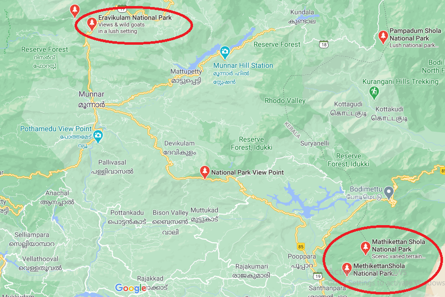
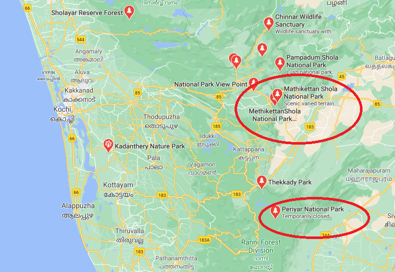
• All the national parks are in Kerala and below shown in attached images the location of all National Parks from north to south.
• Covid-19 negative certificate must for Sabarimala pilgrims from tomorrow, The Sabarimala Temple is a temple complex located at sabarimala inside the Periyar Tiger Reserve in the Perinad Village, Pathanamthitta district, Kerala, India.
• It is one of the largest annual pilgrimage sites in the world with an estimate of over 40 to 50 million devotees visiting every year.• Eravikulam National Park is a 97 km² national park located along the Western Ghats in the Idukki district of Kerala in India. Situated between 10º05’N and 10º20′ north, and 77º0′ and 77º10′ east, it is the first national park in Kerala. The government of Kerala resumed control in 1971 (Kannan Devan Hill Produce (Resumption of lands) Act, 1971), and declared the Eravikulam-Rajamala Wildlife Sanctuary in 1975 to protect the habitat of the endangered Nilgiri tahr. It became a National Park in 1978.

• Mathikettan Shola National Park is a 12.82 km² national park in Poopara village of Udumbanchola taluk in Idukki district of Kerala state, South India. The name Mathikettan derives from the Tamil word literally meaning ‘mind confuser’, as the local people say that one forgets the path once he enters into the park. It notified as a national park to protect the wildlife and rich biodiversity of the area. The Shola forest in the area is bestowed with unit with geological fauna and flora and geomorphological wealth.

• Periyar National Park, also known as Periyar Tiger Reserve, is in the mountainous Western Ghats of Kerala, southern India. This wildlife sanctuary is home to tigers and a significant elephant population, as well as rare lion-tailed macaques, sambar deer, leopards and Indian bison. In the park’s north, Periyar Lake is popular for boat rides. Farther north, spice plantations surround the town of Kumily.
• Robinson, the first game warden. The game sanctuary covered an area of about 500 sq km. In 1950, some more area was added to create the Periyar Wildlife Sanctuary. In 1978, the sanctuary was included in the Central Government initiative known as Project Tiger and was renamed the Periyar Tiger Reserve.IncorrectAns;- d) 1-3-2
Explanation;-
• All the national parks are in Kerala and below shown in attached images the location of all National Parks from north to south.
• Covid-19 negative certificate must for Sabarimala pilgrims from tomorrow, The Sabarimala Temple is a temple complex located at sabarimala inside the Periyar Tiger Reserve in the Perinad Village, Pathanamthitta district, Kerala, India.
• It is one of the largest annual pilgrimage sites in the world with an estimate of over 40 to 50 million devotees visiting every year.• Eravikulam National Park is a 97 km² national park located along the Western Ghats in the Idukki district of Kerala in India. Situated between 10º05’N and 10º20′ north, and 77º0′ and 77º10′ east, it is the first national park in Kerala. The government of Kerala resumed control in 1971 (Kannan Devan Hill Produce (Resumption of lands) Act, 1971), and declared the Eravikulam-Rajamala Wildlife Sanctuary in 1975 to protect the habitat of the endangered Nilgiri tahr. It became a National Park in 1978.

• Mathikettan Shola National Park is a 12.82 km² national park in Poopara village of Udumbanchola taluk in Idukki district of Kerala state, South India. The name Mathikettan derives from the Tamil word literally meaning ‘mind confuser’, as the local people say that one forgets the path once he enters into the park. It notified as a national park to protect the wildlife and rich biodiversity of the area. The Shola forest in the area is bestowed with unit with geological fauna and flora and geomorphological wealth.

• Periyar National Park, also known as Periyar Tiger Reserve, is in the mountainous Western Ghats of Kerala, southern India. This wildlife sanctuary is home to tigers and a significant elephant population, as well as rare lion-tailed macaques, sambar deer, leopards and Indian bison. In the park’s north, Periyar Lake is popular for boat rides. Farther north, spice plantations surround the town of Kumily.
• Robinson, the first game warden. The game sanctuary covered an area of about 500 sq km. In 1950, some more area was added to create the Periyar Wildlife Sanctuary. In 1978, the sanctuary was included in the Central Government initiative known as Project Tiger and was renamed the Periyar Tiger Reserve.


