Contents
- India’s Foreign Trade: March 2020
- Study to identify biomarkers to predict progression
- Integrated geospatial platform
INDIA’S FOREIGN TRADE: MARCH 2020
Focus: GS-III Indian Economy – Do not focus on numbers, just the trends
Why in news?
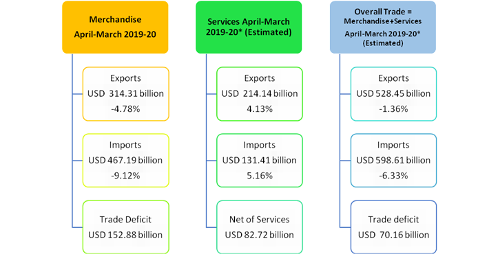
- India’s overall exports (Merchandise and Services combined) in April-March2019-20* are estimated to be USD 528.45billion, exhibiting a negative growth of (-) 1.36per cent over the same period last year.
- Overall imports in April-March 2019-20* are estimated to be USD 598.61billion, exhibiting a negative growth of (-)6.33per cent over the same period last year.

Merchandise trade Exports:
- Exports in March 2020 were USD 21.41 billion, as compared to USD 32.72 billion in March 2019, exhibiting a negative growth of (-) 34.57per cent.
- The decline in exports has been mainly due to the ongoing global slowdown, which got aggravated due to the current Covid-19 crisis.
- The latter resulted in large scale disruptions in supply chains and demand resulting in cancellation of orders.
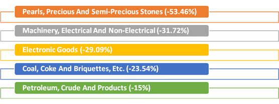
- Except for Iron ore, which registered a growth of 58.43%, all other commodity/commodity groups have registered negative growth in March 2020 vis-a-vis March 2019.
Merchandise Imports

- Cumulative value of imports for the period April-March 2019-20 was USD 467.19 billion (Rs.33,07,977.05crore), as against USD 514.08 billion (Rs.35,94,674.61 crore) during the period April-March 2018-19, registering a negative growth of (-)9.12per cent in Dollar terms.
- Oil imports in April-March 2019-20 were USD129.43billion (Rs. 9,17,306.25crore) which was 8.15per cent lower in Dollar terms (6.99percent lower in Rupee terms) compared to USD140.92billion (Rs. 9,86,275.06crore), over the same period last year.
Exports and Imports in Services
- As per the latest press release by RBI dated 15th April 2020, exports in February2020 were USD 17.73billion (Rs. 1,26,713.37crore) registering a positive growth of 6.88per cent in dollar terms.
- As per the latest press release by RBI dated 15th April 2020, imports in February 2020 were USD 11.07billion (Rs. 79,116.32crore) registering a positive growth of 12.82per cent in dollar terms
STUDY TO IDENTIFY BIOMARKERS TO PREDICT PROGRESSION
Focus: GS-III Science and Technology, Prelims
Why in news?
- The Science and Engineering Research Board (SERB), a statutory body under the Department of Science and Technology (DST), will support exploration of metabolomics alteration in COVID-19 infected patients conducted by IIT Bombay in collaboration with some hospitals in Mumbai.
- The Board was set up for promoting basic research in science and engineering and to provide financial assistance to scientists, academic institutions, R&D laboratories, industrial concerns and other agencies for such research.
- The Board has schemes for funding extramural research, for providing grants for start-up research and for using the scientific expertise of retired scientists.
- The study will identify potential biomarker candidates to predict progression from non-severe to severe COVID-19 conditions.
- Search for potential diagnostic candidates will involve metabolite profiling of different patient groups with various complications.
- Metabolites are small biomolecules, capable of regulating various pathways in all the living-organisms.
- This is a very interesting approach to differentiate between the mild and severe cases of COVID-19 based on the determination of biomarkers from detailed metabolome or proteome investigations. If successful, it could help both in advanced diagnostic and therapeutic strategies
What is a Biomarker?
- A bio-marker, or biological marker is a measurable indicator of some biological state or condition.
- Biomarkers are often measured and evaluated to examine normal biological processes, pathogenic processes, or pharmacologic responses to a therapeutic intervention.
- Biomarkers are used in many scientific fields.
- The use of biomarkers in basic and clinical research as well as in clinical practice has become so commonplace that their presence as primary endpoints in clinical trials is now accepted almost without question.
- In the case of specific biomarkers that have been well characterized and repeatedly shown to correctly predict relevant clinical outcomes across a variety of treatments and populations, this use is entirely justified and appropriate.
INTEGRATED GEOSPATIAL PLATFORM
Focus: GS-III Science and Technology
Why in news?
- The Department of Science and Technology (DST), Government of India, has created an Integrated Geospatial Platform out of available geospatial datasets, standards-based services, and analytic tools to help decision making during the current COVID-19 outbreak and aid devising area-specific strategies to handle the socio-economic impact in the recovery phase.
- The platform is initially expected to strengthen the public health delivery system of the State and Central Governments and subsequently provide the necessary geospatial information support to citizens and agencies dealing with the challenges related to health, socio-economic distress, and livelihood challenges.
- The mobile application SAHYOG, as well as the web portal prepared & managed by the Survey of India (SoI), has been customized to collect COVID-19 specific geospatial datasets through community engagement to augment the response activities by Government of India to the pandemic.
- Information parameters required as per the Govt of India strategy and containment plan for large outbreaks have been incorporated in the SAHYOG application.
What are geospatial technologies?
- Geospatial is a term widely used to describe the combination of spatial software and analytical methods with terrestrial or geographic datasets. The term is often used in conjunction with geographic information systems and geomatics, never separately.
- “Geospatial technologies” is a term used to describe the range of modern tools contributing to the geographic mapping and analysis of the Earth and human societies.
- These technologies have been evolving in some form since the first maps were drawn in prehistoric times.
- In the 19th century, the long important schools of cartography and mapmaking were joined by aerial photography as early cameras were sent aloft on balloons and pigeons, and then on airplanes during the 20th century.
- The science and art of photographic interpretation and map making was accelerated during the Second World War and during the Cold War it took on new dimensions with the advent of satellites and computers.
- Satellites allowed images of the Earth’s surface and human activities therein with certain limitations.
- Computers allowed storage and transfer of imagery together with the development of associated digital software, maps, and data sets on socioeconomic and environmental phenomena, collectively called geographic information systems (GIS).


