Context:
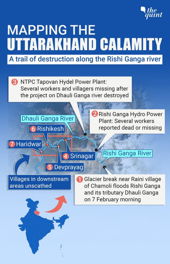
The Geological Survey of India said that the flash flood (February 2021) in Chamoli district, Uttarakhand was due to large mass of snow, ice and rock avalanche along with a hanging mass of rock crashing into the Raunthi Garh valley floor.
Relevance:
GS-III: Disaster Management, GS-I: Geography (Physical Geography, Important Geophysical Phenomena),
Dimensions of the Article:
- About the Chamoli Disaster
- Cause of the Chamoli Flash flood according to the GSI
- Why is the Chamoli incident of concern?
- What is an Avalanche?
- About the Geological Survey of India (GSI)
About the Chamoli Disaster
- A flash flood in the Rishi Ganga river, a tributary of the Alaknanda in Chamoli district of Uttarakhand, on February 7, washed away a functional small hydroelectric project and destroyed the under-construction 520 MW Tapovan Vishnugad project of the NTPC on the Dhauli Ganga river. The flash flood also claimed at least 72 lives and caused at least 200 to be missing or dead.

Cause of the Chamoli Flash flood according to the GSI
- The Geological Survey of India (GSI) said that the flash flood was caused due to a large mass of snow, ice and rock avalanche along with a hanging mass of rock crashing into the Raunthi Garh valley floor.
- This impact pulverised the combination of rock, snow and ice causing a rapid flow downstream of Raunthi Garh and into the Rishiganga valley leading to the deluge.
- A contributory factor, according to a senior scientist at the GSI, was unusually warm weather in the region – Observed change in the hydro-meteorological conditions such as heavy snowfall followed by sudden warmer climate possibly triggered this huge snow and rock avalanche/landslide causing sudden domino effect of flash flood in the downstream.
- Climate change, that was triggering higher temperatures in the upper reaches of the Himalaya had a role and the constant freezing and thawing of ice made parts of rocks weak making them vulnerable to collapse.
- There was no evidence of a Glacial Lake Outburst Flood (GLOF) having caused the event.
Why is the Chamoli incident of concern?
- Deep movement of rock assemblages: Uttarakhand, which gained a distinct identity in the year 2000 as a separate State carved out from Uttar Pradesh, is geologically unique. As a part of the lesser Himalaya, in the populated terrane — a region bounded by earth faults — it remains active in terms of deep movement of rock assemblages.
- Convergence boundary of two continental plates: As the northward moving peninsular India presses on, the lesser Himalaya rock assemblages are compressed and are pushed under the huge pile of the Great Himalayan rocks, the latter riding southwards onto and over the lesser Himalaya.
- The Main Central Thrust: The MCT, running east-west along the Himalaya, is where the Indian and Eurasian plates connect. The result of these geological stresses, scientists say, is weakening of rocks, making the development of large dam projects in the region unwise.
- Construction of dams: In an assessment of the proposed 315-metre-high India-Nepal Pancheshwar dam project across the Kali river in the Kumaon region, with a drainage area of 12,000 sq. km, Shubhra Sharma and colleagues wrote in Current Science in 2019 that the chosen site could witness a strong earthquake in the Nepal area from the Rangunkhola Fault, perhaps of a magnitude of 7.4, with a potentially serious fallout.
- Weak rocks: The geology of mountains in many parts of Uttarakhand is such that the threat of landslides is high. Rocks here have been weakened by natural processes across time and are vulnerable to intense rainfall as well as human interference, in the form of house-building and road construction.
What is an Avalanche?
- An avalanche (also called a snowslide) is a rapid flow of snow down a slope, such as a hill or mountain.
- Avalanches can be set off spontaneously, by such factors as increased precipitation or snowpack weakening, or by external means such as humans, animals, and earthquakes.
- Primarily composed of flowing snow and air, large avalanches have the capability to capture and move ice, rocks, and trees.
- Though they share similarities at first, avalanches are distinct from slushflows, mudslides, rock slides, and serac collapses. They are also different from large scale movements of ice.
About the Geological Survey of India (GSI)
- The Geological Survey of India (GSI) was founded in 1851 and it is an attached office to the Ministry of Mines.
- The GSI was founded for: (i) Conducting geological surveys and studies of India and (ii) Acting as a prime provider of basic earth science information to government, industry and general public, as well as the official participant in steel, coal, metals, cement, power industries and international geoscientific forums.
- The main functions of GSI relate to creation and updation of national geoscientific information and mineral resource assessment.
- These objectives are achieved through ground surveys, air-borne and marine surveys, mineral prospecting and investigations, multi-disciplinary geoscientific, geo-technical, geo-environmental and natural hazards studies, glaciology, seismotectonic study, and carrying out fundamental research.
- Outcome of work of GSI has immense societal value. Functioning and annual programmes of GSI assume significance in the national perspective.
- GSI, headquartered at Kolkata, has six Regional offices located at Lucknow, Jaipur, Nagpur, Hyderabad, Shillong and Kolkata and State Unit offices in almost all States of the country.
-Source: The Hindu


