Contents
- Western Ghats offer major additions to new flora
- Gupta era temple in Uttar Pradesh
- SCO summit 2021
- Lake Tanganyika’s rise: Reason for 84% internal migration
Western Ghats offer major additions to new flora
Context:
The Botanical Survey of India, in its new publication Plant Discoveries 2020 has added 267 new taxa/ species to the country’s flora. Of these newly discovered plants – 22% of the discoveries were made from the Western Ghats.
Relevance:
GS-III: Environment and Ecology (Conservation of Ecology, Important Protected regions, Species in news), Prelims
Dimensions of the Article:
- About Western Ghats
- Importance of Western Ghats
- Facts About Western Ghats for Prelims
- Background on Declaration of Western Ghats (WG) region as Ecologically Sensitive Area (ESA)
- What are Eco-Sensitive Zones?
- What does Declaration of Western Ghats as ESA mean?
- Highlights of New species listed by the Botanical Survey of India
- About the Botanical Survey of India (BSI)
About Western Ghats
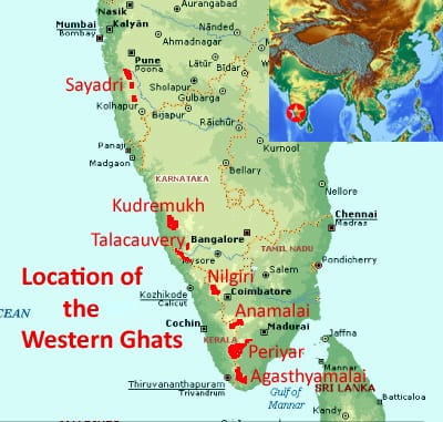
- The Western Ghats, also known as Sahyadri are a mountain range that covers an area of 140,000 square kilometres parallel to the western coast of the Indian peninsula.
- It traverses the states of Kerala, Tamil Nadu, Karnataka, Goa, Maharashtra and Gujarat.
- It is a UNESCO World Heritage Site and is one of the eight “hottest hot-spots” of biological diversity in the world.
- According to UNESCO, the Western Ghats are older than the Himalayas.

Importance of Western Ghats
- A total of thirty-nine areas in the Western Ghats, including national parks, wildlife sanctuaries and reserve forests, were designated as world heritage sites in 2012 – twenty in Kerala, ten in Karnataka, five in Tamil Nadu and four in Maharashtra.
- They influence Indian monsoon weather patterns by intercepting the rain-laden monsoon winds that sweep in from the south-west during late summer.
- The dense forests also contribute to the precipitation of the area by acting as a substrate for condensation of moist rising orographic winds from the sea.
- The northern portion of the narrow coastal plain between the Western Ghats and the Arabian Sea is known as the Konkan, the central portion is called Kanara and the southern portion is called Malabar.
- The Western Ghats form one of the four watersheds of India, feeding the perennial rivers of India.
- The major river systems originating in the Western Ghats are the Godavari, Kaveri, Krishna, Thamiraparani and Tungabhadra rivers.
Facts About Western Ghats for Prelims
- Western Ghats are continuous range of mountains (Gaps exist, but not like the Eastern Ghats)
- Major gaps in the range are the Goa Gap, between the Maharashtra and Karnataka sections, and the Palghat Gap on the Tamil Nadu and Kerala border between the Nilgiri Hills and the Anaimalai Hills.
- The Western Ghats meet the Eastern Ghats at the Nilgiri mountains in north-western Tamil Nadu.
- Evergreen Forests are found here.
- Anaimudi is the highest peak.
- Western Ghats are older than Himalayas.
- Nilgiri Biosphere is the most famous Biosphere reserve in WG.
- Local Names for western ghats are: Sahyadri in Maharashtra, Nilgiri hills in Karnataka and Tamil Nadu, Anaimalai hills and Cardamom hills in Kerala.
Background on Declaration of Western Ghats (WG) region as Ecologically Sensitive Area (ESA)
- In 2010, the Western Ghats Ecology Expert Panel (WGEEP), also known as the Gadgil Commission, recommended that all of the Western Ghats should be declared as the ESA with only limited development allowed in graded zones. It classified the Western Ghats into ESA 1, 2 and 3 of which ESA-1 is a high priority zone where almost all of the developmental activities (mining, thermal power plants, etc) should be restricted. It was criticised for being more environment-friendly and not in tune with the ground realities.
- In 2012, the Kasturirangan Committee sought to balance the development and environment protection in contrast to the system proposed by the Gadgil report – hence, the committee recommended that instead of the total area of Western Ghats, only 37% of the total area to be brought under ESA. Another recommendation of the committee was that NO thermal power projects are to be allowed, hydropower projects are to be allowed only after detailed study and a complete ban on mining, quarrying and sand mining in ESA.
- A draft notification was issued in 2018 mentioning the areas to be notified in the ESA – which is spread over six states of Gujarat, Maharashtra, Goa, Karnataka, Kerala and Tamil Nadu.
- However, the 6 states asked centre to expedite the process to notify the ESAs in the global biodiversity hotspot for clarity – i.e., the states expressed their views as regards activities and extent of area mentioned in the said notification.
- It was decided that state specific issues shall be further deliberated so as to arrive at a consensus on the issue.
What are Eco-Sensitive Zones?
- Eco Sensitive Zones are fragile areas around protected areas declared by the Ministry of Environment, Forest, and Climate Change (MoEFCC).
- They are areas notified by the MoEFCC around Protected Areas, National Parks and Wildlife Sanctuaries.
- The purpose of declaring ESZs is to create some kind of “shock absorbers” to the protected areas by regulating and managing the activities around such areas.
- Among activities prohibited in the eco-sensitive zone are hydroelectric projects, brick kilns, commercial use of firewood and discharge of untreated effluents in natural water bodies or land areas.
- No new commercial hotels and resorts shall be permitted within 1 km of the boundary of the protected area or up to the extent of the eco-sensitive zone, whichever is nearer, except for small temporary structures for eco-tourism activities.

What does Declaration of Western Ghats as ESA mean?
- In the ESA, all kinds of mining activities, thermal power plants and highly polluting industries would no longer be allowed.
- The existing mines shall be phased out within five years from the issue of final notification or on the expiry of the existing mining lease, whichever is earlier.
- All new ‘Red’ category industries and the expansion of such existing industries shall be banned.
- Other kinds of projects and activities, like operation of hydropower plants, and ‘orange’ category of industries, will be strictly regulated in the ESA.
- New expansion projects of building and construction with built-up area of 20,000 square meters and above shall be prohibited too.
Highlights of New species listed by the Botanical Survey of India
- The Botanical Survey of India (BSI) has added 267 new taxa/species to the country’s flora, of which:
- Highest contribution of discoveries is from the Western Ghats 22%
- Western Himalayas 15%
- Eastern Himalayas 14%
- Northeast Ranges 12%
- West coast contributed 10%
- East Coast contributed 9%
- Eastern Ghats 4%
- South Deccan 4%
- Central Highland 3%
- North Deccan 3%.
- One new monogeneric family Hanguanaceae has been recorded for the first time from India.
- Nine new species of balsam (Impatiens) and one species of wild banana (Musa pradhanii) were discovered from Darjeeling.
- One species of wild jamun (Syzygium anamalaianum) was recorded from Coimbatore in Tamil Nadu.
- A species of fern (Selaginella odishana) was recorded from Kandhamal in Odisha.
- There are 14 new macro and 31 new micro fungi species recorded from various parts of India.
About the Botanical Survey of India (BSI)
- The Botanical Survey of India (BSI) was founded in 1890 (formally instituted by East India Company (EIC)) – located in Kolkata, West Bengal.
- BSI is the Ministry of Environment, Forest and Climate Change’s organization for survey, research and conservation of plant wealth of India, flora and endangered species of India, including by czollecting and maintaining germplasm and gene bank of endangered, patent and vulnerable plant species.
BSI’s Important Publications:
- Flora of India series books,
- States floras,
Flora of Protected regions - Red Data Book of Indian Plants
- Plant Discoveries (annual publication with most authentic information on India’s plant wealth)
-Source: The Hindu
Gupta era temple in Uttar Pradesh
Context:
The Archaeological Survey of India (ASI) discovered remains of an ancient temple dating back to the Gupta period (5th century) in a village in Uttar Pradesh’s Etah district.
Relevance:
Prelims, GS-I: History, GS-I: Art and Culture
Dimensions of the Article:
- About the Gupta Empire
- About the ASI Discovery in Uttar Pradesh
- What is the Shankhalipi script?
About the Gupta Empire
- The Gupta Empire was an ancient Indian empire which existed from the early 4th century CE to late 6th century CE.
- This period is considered as the Golden Age of India by historians.
- The ruling dynasty of the empire was founded by the king Sri Gupta; the most notable rulers of the dynasty were Chandragupta I, Samudragupta, and Chandragupta II alias Vikramaditya.
- The 5th-century CE Sanskrit poet Kalidasa credits the Guptas with having conquered about twenty-one kingdoms, both in and outside India, including the kingdoms of Parasikas, the Hunas, the Kambojas, tribes located in the west and east Oxus valleys, the Kinnaras, Kiratas, and others.
- Many of the literary sources, such as Mahabharata and Ramayana, were canonized during this period.
- The Gupta period produced scholars such as Kalidasa, Aryabhata, Varahamihira, and Vatsyayana who made great advancements in many academic fields.
About the ASI Discovery in Uttar Pradesh
- Two pillars were excavated on which there is an inscription about Kumaragupta I, the powerful ruler of Gupta dynasty, in ‘sankh lipi’ (conch script or shell script) typical of the 5th century AD.
- The Guptas were the first to build structural temples, distinctly different from the ancient rock-cut temples.
- ASI conducted further excavation and found stairs that led to a structural temple built during the Gupta period. He says the inscription on the stairs possibly reads ‘Sri Mahendraditya’, which was the title of Kumaragupta I.
- The discovery becomes significant since only two other structural temples from the Gupta age have been found so far — Dashavatara Temple (Deogarh) and Bhitargaon Temple (Kanpur Dehat).
What is the Shankhalipi script?
- Shankhalipi or “shell-script” is a term used by scholars to describe ornate spiral characters assumed to be Brahmi derivatives that look like conch shells or shankhas.
- They are found in inscriptions across north-central India and date to between the 4th and 8th centuries.
- Both Shankhalipi and Brahmi are stylised scripts used primarily for names and signatures.
- The inscriptions consist of a small number of characters, suggesting that the shell inscriptions are names or auspicious symbols or a combination of the two.
- The script was discovered in 1836 on a brass trident in Uttarakhand’s Barahat by English scholar James Prinsep, who was the founding editor of the Journal of the Asiatic Society of Bengal.
- Prominent sites with shell inscriptions include the Mundeshwari Temple in Bihar, the Udayagiri Caves in Madhya Pradesh, Mansar in Maharashtra and some of the cave sites of Gujarat and Maharashtra.
-Source: Indian Express
SCO summit 2021
Context:
The 21st Summit of the Shanghai Cooperation Organisation (SCO) Council of Heads of State was held via video Conferencing in Dushanbe, Tajikistan.
Relevance:
GS-II: International Relations (Important International Organizations and groupings, Foreign Policies affecting India’s Interests)
Dimensions of the Article:
- Shanghai Cooperation Organisation (SCO)
- Highlights of the 21st Summit of the SCO
Shanghai Cooperation Organisation (SCO)
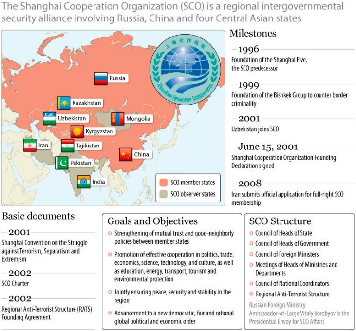
- The Shanghai Cooperation Organisation (SCO) is a Eurasian political, economic, and security alliance which was formed in 2001 in Shanghai, China.
- The SCO is the largest regional organisation in the world in terms of geographical coverage and population, covering three-fifths of the Eurasian continent and nearly half of the human population.
- The leaders of China, Kazakhstan, Kyrgyzstan, Russia, Tajikistan, and Uzbekistan were involved in the formation. (Prior to the creation of SCO in 2001, Kazakhstan, China, Kyrgyzstan, Russia and Tajikistan were members of the Shanghai Five.)
- India and Pakistan joined SCO as full members in 2017. (India was made an observer at the SCO in 2005 and has generally participated in the ministerial-level meetings of the grouping which focus mainly on security and economic cooperation in the Eurasian region.)
- Iran has been accepted as the ninth full member of the organization in the 21st Summit in 2021.
- Official Languages of the SCO are Russian and Chinese.
- SCO Secretariat in Beijing and Executive Committee of the Regional Anti-Terrorist Structure (RATS) in Tashkent are the Permanent Bodies of the SCO.
- The Chairmanship of the SCO is by rotation for a year by Member States.
- The Headquarters of the SCO is in Chaoyang District, Beijing, China.

- The Heads of State Council (HSC) is the supreme decision-making body in the SCO, it meets once a year and adopts decisions and guidelines on all important matters of the Organisation
- The SCO is widely regarded as the “alliance of the East”, due to its growing centrality in Asia-Pacific. It is seen as a counterweight to North Atlantic Treaty Organization (NATO), It is a nine-member economic and security bloc and has emerged as one of the largest transregional international organisations.
- The Heads of State Council (HSC) is the supreme decision-making body in the SCO, it meets once a year and adopts decisions and guidelines on all important matters of the organisation.
- The Council of Heads of Government is the second-highest council in the organisation.
- Military exercises are also regularly conducted among members to promote cooperation and coordination against terrorism and other external threats, and to maintain regional peace and stability.
Highlights of the 21st Summit of the SCO
- At the meet the focus was primarily on the ground situation in Afghanistan and its global repercussions.
- Iran has been accepted as the ninth full member of the organisation.
- India took a strong stance against radicalisation and extremism, urging the panel to come up with a joint approach and frame a code of conduct to stop terror financing and cross-border terrorism. It also stressed upon the importance of moderate Islam in Central Asia.
- India also flagged concerns over the serious humanitarian crisis unfolding in Afghanistan, noting that the economic woes of the Afghan people are increasing due to the blockage in financial and trade flows.
- India pointed out that the developments in the country could lead to an uncontrolled flow of drugs, illegal weapons and human trafficking.
-Source: Indian Express, PIB
Lake Tanganyika’s rise: Reason for 84% internal migration
Context:
Climate shocks, mainly the rapid and significant rise of Lake Tanganyika, caused at least 84 per cent internal migration in East Africa’s Burundi in the recent years.
Relevance:
Prelims (Maps), GS-III: Environment and Ecology (Impact of Climate Change), GS-I: Geography
Dimensions of the Article:
- About Lake Tanganyika
- About internal displacement in East Africa’s Burundi
About Lake Tanganyika
- Lake Tanganyika is an African Great Lake – the second-oldest freshwater lake in the world.
- Lake Tanganyika is the second-largest by volume, and the second-deepest, in all cases after Lake Baikal in Siberia.
- It is also the world’s longest freshwater lake.
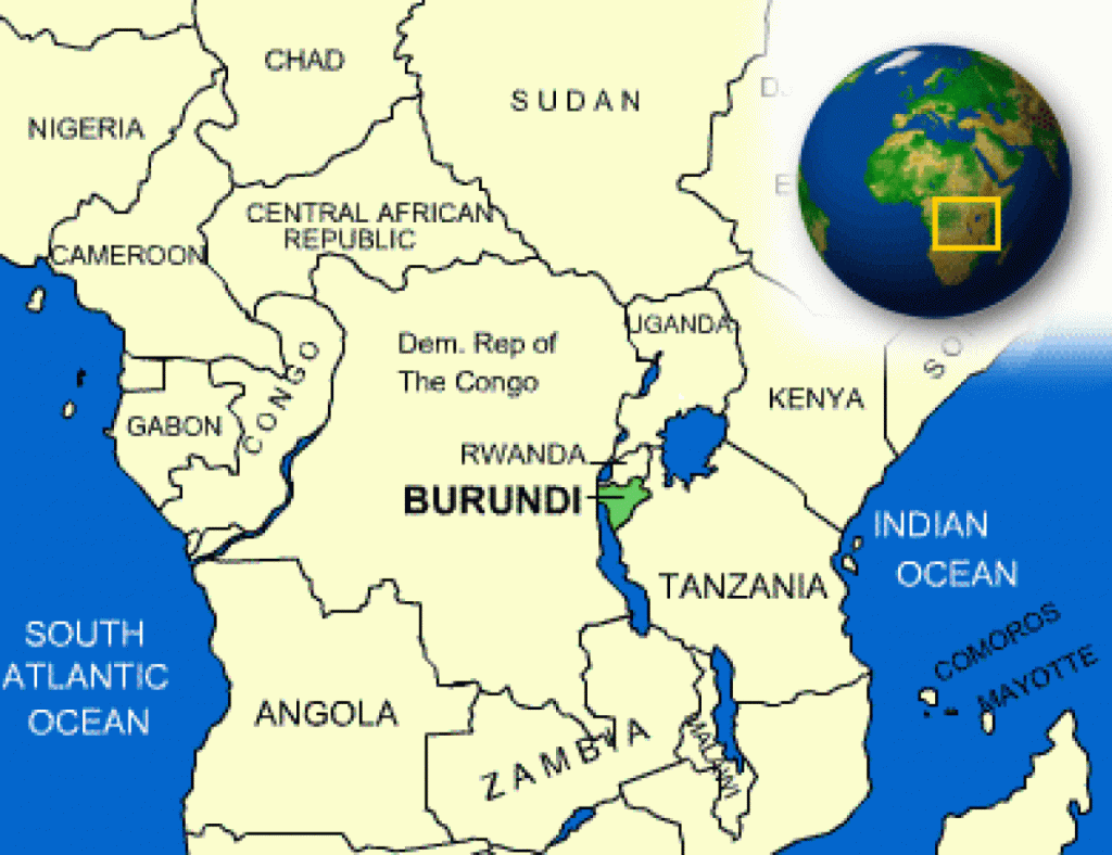
- The lake is shared between four countries—Tanzania, the Democratic Republic of the Congo (DRC), Burundi, and Zambia.
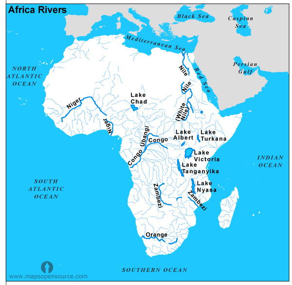
- It drains into the Congo River system and ultimately into the Atlantic Ocean.


About internal displacement in East Africa’s Burundi
- Burundi is among the 20 countries most vulnerable to climate change. It has the most people living along the shores of Lake Tanganyika among the four countries bordering it.
- Lake Tanganyika rose to 776.4 metres (4 meters above average) above sea level in April 2021 due to heavy storms and subsequent flooding and landslides. Several homes and farms were inundated as a consequence.
- During the past two years, persistent heavy rain, followed by floods, landslides and strong winds, raised Lake Tanganyika to dangerous levels.
- Burundi faces the burden of impacts of global emissions and is very poorly adapted to climate change (ranked 171 out of 181 countries in the 2015 Notre Dame Global Adaptation Index).
-Source: Down to Earth Magazine


