CONTENTS
- Focus on Fiscal Decentralisation and Urban Financial Sustainability by the 16th Finance Commission
- Cauvery River
- Successful Conclusion of Global INDIAai Summit and IMF’s AI Preparedness Index Launch
- Revival Hopes for Gharials in Kaziranga National Park
- Common Grass Yellow
- Palm Trees
Focus on Fiscal Decentralisation and Urban Financial Sustainability by the 16th Finance Commission
Context:
Recent developments surrounding the 16th Finance Commission (FC) in India underscore crucial issues related to fiscal decentralisation, especially concerning urban areas and their financial sustainability within the federal structure. Additionally, the World Bank has estimated a need for USD 840 billion for basic urban infrastructure over the next decade.
Relevance:
GS II: Polity and Governance
Dimensions of the Article:
- Financial Sustainability Issues with Urban Areas in India
- Major Terms of Reference for the 16th Finance Commission
- Steps Needed for Better Urban Finance
Financial Sustainability Issues with Urban Areas in India:
- Significance of Urban Areas:
- India’s urban areas contribute 66% of the country’s GDP and about 90% of total government revenues, yet they face significant infrastructure and financial challenges.
- Inadequate Fiscal Support:
- Intergovernmental transfers (IGTs) to cities constitute only 0.5% of GDP, impacting their ability to provide essential services and maintain infrastructure.
- Comparison with Other Nations:
- Compared to other developing nations, India allocates significantly lower funds to Urban Local Bodies (ULBs). For example, South Africa allocates 2.6%, Mexico 1.6%, the Philippines 2.5%, and Brazil 5.1% of their GDPs to their cities.
- Impact of GST:
- The introduction of GST has reduced ULBs’ own tax revenues, exacerbating financial challenges in urban areas.
- Revenue Decline and Expenditure Rise:
- An RBI survey (2020-21) of 221 municipal corporations revealed that over 70% experienced revenue declines, while expenditures rose sharply by 71.2%.
- Property Tax Issues:
- As per OECD, India has the world’s lowest property tax collection rate (property tax to GDP ratio), limiting municipal corporation revenues.
- Impact of GST on Revenue Streams:
- GST abolished octroi, which previously contributed significantly (about 55% of total revenue expenditure) to urban local bodies’ revenues, leading to a decline in tax revenues.
Other Issues:
- Data Challenges:
- Outdated census data (last updated in 2011) hampers accurate assessment of urban population needs, crucial for fiscal planning and addressing urbanization trends.
- Parallel Agencies and Schemes:
- MP/MLA Local Area Development Funds undermine local government autonomy, complicating urban governance and service delivery.
- Pandemic Response and Governance:
- During the pandemic, municipal corporations were excluded from disaster mitigation decision-making at national, state, and district levels, impacting effective urban governance.
- Policy Paradigm and Local Government Autonomy:
- The traditional approach treating local governments as extensions of state governments persists, limiting local autonomy and effective service delivery.
- Infrastructure and Human Resource Deficits:
- Some urban local governments lack basic infrastructure and human resources, exacerbated by irregular elections in some states, impacting service delivery and governance effectiveness.
Major Terms of Reference for the 16th Finance Commission:
- Constitutional Mandate:
- Established under Article 280 of the Indian Constitution to recommend the distribution of financial resources between the central government and state governments.
- Tax Distribution:
- Recommending the distribution of taxes between the Union Government and the States, including the allocation of shares among the States from tax proceeds.
- Grants-in-Aid:
- Establishing principles governing grants-in-aid to States from the Consolidated Fund of India, determining amounts under Article 275 of the Constitution.
- Enhancing State Funds:
- Identifying measures to enhance the Consolidated Fund of a State to supplement resources available to Panchayats and Municipalities based on State Finance Commission recommendations.
- Disaster Management Financing:
- Reviewing financing structures related to Disaster Management initiatives, including funds under the Disaster Management Act, 2005, and recommending improvements.
Steps Needed for Better Urban Finance:
- Property Tax Augmentation:
- Implementing Geographical Information System (GIS) and digitization for better property tax administration, as recommended by previous Finance Commissions.
- Levy of Vacant Land Tax:
- Empowering municipalities to levy vacant land tax to optimize revenue sources.
- Digital Transformation:
- Adopting digital platforms for property tax assessment, e-filing, and online payments to enhance transparency and collection efficiency.
- User Charges for Services:
- Introducing user charges for specific services like parking, waste collection for bulk generators, and recreation facilities, ensuring fees reflect service costs.
- Public-Private Partnerships (PPPs):
- Monetizing underutilized properties through PPPs to develop commercial spaces, markets, or parking lots, generating rental income and economic activity.
- Support for Local Economy:
- Streamlining business licenses, offering tax incentives for startups, and fostering innovation hubs to boost local economic activity and tax revenues.
- Social Stock Exchange (SSE):
- Exploring the creation of an SSE or partnering with existing SSEs to attract investment towards social enterprises addressing local social needs.
- Land Value Capture:
- Implementing mechanisms to capture increased land values resulting from public infrastructure projects to fund future developments, as exemplified by cities like Hong Kong.
-Source: The Hindu
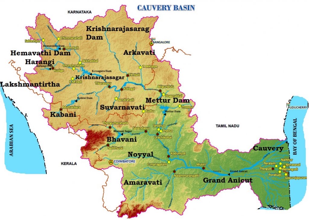
Cauvery River
Context:
The Karnataka state government has established a nine-member committee to investigate the contamination of the Cauvery River.
Relevance:
GS-II: Polity and Governance (Intra-State Relations, Functions & responsibilities of the Union and the States, Issues and challenges of federal structure)
Dimensions of the Article:
- About the Cauvery River
- Cauvery Water Management Authority (CWMA)
- Cauvery Water Regulation Committee (CWRC)
About the Cauvery River
- The Cauvery River (Kaveri), designated as the ‘Dakshina Ganga’ or ‘the Ganga of the South’, flows in a southeasterly direction through the states of Karnataka and Tamil Nadu and descends the Eastern Ghats in a series of great falls.
- Before emptying into the Bay of Bengal south of Cuddalore, Tamil Nadu the river breaks into a large number of distributaries forming a wide delta called the “Garden of Southern India”
- The Cauvery basin extends over states of Tamil Nadu, Karnataka, Kerala, and Union Territory of Puducherry draining an area of 81 thousand Sq.km.
- It is bounded by the Western Ghats on the west, by the Eastern Ghats on the east and the south, and by the ridges separating it from the Krishna basin and Pennar basin on the north.
- The Nilgiris, an offshore of Western ghats, extend Eastwards to the Eastern ghats and divide the basin into two natural and political regions i.e., Karnataka plateau in the North and the Tamil Nadu plateau in the South.
- Physiographically, the basin can be divided into three parts – the Westen Ghats, the Plateau of Mysore, and the Delta.
- The delta area is the most fertile tract in the basin. The principal soil types found in the basin are black soils, red soils, laterites, alluvial soils, forest soils, and mixed soils. Red soils occupy large areas in the basin. Alluvial soils are found in the delta areas.
- It is almost a perennial river with comparatively fewer fluctuations in flow and is very useful for irrigation and hydroelectric power generation because its upper catchment area receives rainfall during summer by the south-west monsoon and the lower catchment area during the winter season by the retreating north-east monsoon.
- Harangi, Hemavati, Shimsha, and Arkavati are the tributaries on the left bank (north) and Lakshmantirtha, Kabbani, Suvarnavati, Bhavani, Noyil, and Amaravati are the tributaries on the right bank (south).
Cauvery Water Management Authority (CWMA)
- CWMA has been created as per the Cauvery Management Scheme framed by Centre and approved by Supreme Court.
- The Cauvery Management Scheme deals with release of water from Karnataka to Tamil Nadu, Kerala and Puducherry.
- It will be implemented by Cauvery Management Authority (CMA).
- CMA will be sole body to implement CWDT award as modified by Supreme Court.
- The Central Government will have no say in implementing of the scheme except for issuing administrative advisories to it.
- The authority will comprise a chairman, a secretary and eight members.
- Out of the eight members, two will be full time, while two will be part time members from centre’s side. Rest four will be part time members from states.
- The main mandate of the CMA will be to secure implementation and compliance of the Supreme Court’s order in relation to “storage, apportionment, regulation and control of Cauvery waters”.
- CMA will also advise the states to take suitable measures to improve water use efficiency.
- It will do so by promoting use of micro-irrigation, change in cropping patterns, improved farm practices and development of command areas.
- The CMA will also prepare an annual report covering its activities during the preceding year.
Cauvery Water Regulation Committee (CWRC)
- The Central government constituted the Cauvery Water Regulation Committee (CWRC) as per the provisions in the Kaveri Management Scheme laid down by the Supreme Court.
- While the CWMA is an umbrella body, the CWRC will monitor water management on a day-to-day basis, including the water level and inflow and outflow of reservoirs in all the basin states.
-Source: The Hindu
Successful Conclusion of Global INDIAai Summit and IMF’s AI Preparedness Index Launch
Context:
The Global INDIAai Summit, held at Bharat Mandapam in New Delhi, successfully concluded, bringing together experts, policymakers, and enthusiasts to discuss the future of Artificial Intelligence (AI) in India and globally. In another development, the International Monetary Fund (IMF) launched an Artificial Intelligence Preparedness Index (AIPI) Dashboard, tracking the AI readiness of 174 economies worldwide.
Relevance:
GS II: International Relations
Dimensions of the Article:
- Key Highlights and Outcomes of the Summit
- Artificial Intelligence Preparedness Index (AIPI)
Key Highlights and Outcomes of the Summit:
- India’s Leadership in AI Accessibility:
- India showcased its commitment to making AI accessible to all, irrespective of socio-economic backgrounds.
- Emphasized India’s unique approach to shaping AI discourse to meet both domestic needs and global leadership aspirations.
- Platform for Global South’s AI Aspirations:
- Provided a platform for Global South countries to express AI-related concerns and aspirations.
- Acknowledged India’s pivotal role in bridging the AI gap between Global North and South.
- INDIAai Mission’s Commitment:
- Demonstrated India’s dedication to fostering an inclusive AI ecosystem through the INDIAai Mission.
- Focused on core areas like compute capacity, foundational models, datasets, application development, and skills enhancement.
- Global Partnerships and Collaborations:
- Established the Collaborative AI on Global Partnership (CAIGP) to unite GPAI members and AI experts.
- India’s leadership as GPAI’s Lead Chair in 2024 emphasized discussions on trustworthy AI and global AI governance.
- Support for Indian Startups:
- Allocated Rs. 2,000 crore from the INDIAai Mission to support indigenous AI startups.
- Discussed plans for subsidizing GPU infrastructure to enhance AI development capabilities among startups.
- AI Applications in National Priorities:
- Explored AI applications in India’s AgriStack, data-driven credit distribution, and agricultural decision-making.
- Addressed legal frameworks, dataset management, and AI integration in government services to improve efficiency and citizen services.
- Commitment to Responsible AI Development:
- Reaffirmed commitment to human-centric AI development, focusing on transparency, fairness, and ethical AI practices.
- Upheld OECD and UNESCO recommendations on AI ethics and governance.
Artificial Intelligence Preparedness Index (AIPI):
- Evaluation Criteria:
- AIPI assesses countries based on digital infrastructure, human capital, labor policies, innovation capacity, integration readiness, and regulatory frameworks.
- Country Categorization:
- Categorizes countries into Advanced Economies (AE), Emerging Market Economies (EM), and Low-Income Countries (LIC) based on AI readiness.
- Top Performers:
- Countries with advanced digital infrastructure like Singapore, Denmark, and the United States score highest on the index.
- India’s Position:
- Ranked 72nd with a score of 0.49, categorized as an Emerging Market Economy (EM).
- Shows relative strength among its regional peers but trails behind leaders like China in AI preparedness.
-Source: Indian Express, The Hindu, PIB
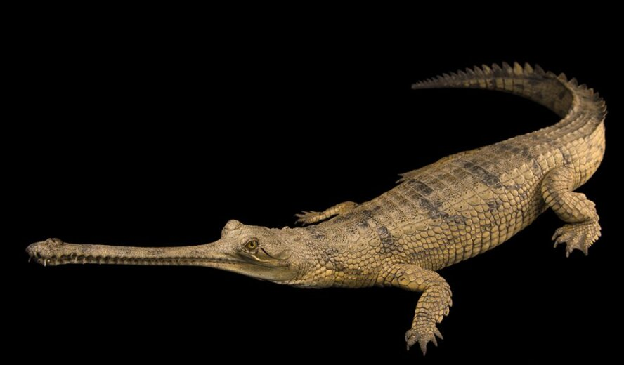
Revival Hopes for Gharials in Kaziranga National Park
Context:
A lone female gharial in Kaziranga National Park and Tiger Reserve, Assam, has sparked hopes for the species’ revival in the Brahmaputra River System (BRS).
Relevance:
GS III: Environment and Ecology
Dimensions of the Article:
- About Gharials
- Kaziranga National Park
About Gharials:
- Description:
- Gharials, also known as gavials, are a type of Asian crocodilian characterized by their long, thin snouts.
- Crocodilians in India:
- India hosts three species of crocodilians:
- Gharial (Gavialis gangeticus): Critically Endangered on the IUCN Red List.
- Mugger crocodile (Crocodylus palustris): Vulnerable.
- Saltwater crocodile (Crocodylus porosus): Least Concern globally, but populations outside India are listed under Appendix II of CITES.
- India hosts three species of crocodilians:
- Legal Protection:
- All three species are listed on Appendix I of CITES and Schedule I of the Wild Life (Protection) Act, 1972, providing them with the highest level of legal protection.
- Habitat of Gharials:
- Natural Habitat: Freshwaters in northern India.
- Primary Habitat: Chambal River (a tributary of Yamuna).
- Secondary Habitats: Ghagra, Gandak River, Girwa River (Uttar Pradesh), Ramganga River (Uttarakhand), and Sone River (Bihar).
- Significance:
- Population of gharials serves as an indicator of clean river water quality due to their sensitivity to pollution.
- Threats:
- Environmental Threats: Increased river pollution, dam construction, and large-scale fishing operations.
- Illegal Activities: Illegal sand mining and poaching pose significant threats to gharial populations.
Kaziranga National Park
- Kaziranga National Park is a national park in the Golaghat, Karbi Anglong and Nagaon districts of the state of Assam.
- It is a World Heritage Site and hosts two-thirds of the world’s great one-horned rhinoceroses.
- Kaziranga is recognized as an Important Bird Area by BirdLife International for conservation of avifaunal species.
- Along with the iconic Greater one-horned rhinoceros, the park is the breeding ground of elephants, wild water buffalo, and swamp deer.
- Over the time, the tiger population has also increased in Kaziranga, and that’s the reason why Kaziranga was declared as Tiger Reserve in 2006.
- Due to the difference in altitude between the eastern and western areas of the park, here one can see mainly four types of vegetation’ like alluvial inundated grasslands, alluvial savanna woodlands, tropical moist mixed deciduous forests, and tropical semi-evergreen forests.
- Kaziranga is a vast expanse of tall elephant grass, marshland, and dense tropical moist broadleaf forests, criss-crossed by four major rivers, including the Brahmaputra, and the park includes numerous small bodies of water.
- Kaziranga has flat expanses of fertile, alluvial soil, formed by erosion and silt deposition by the River Brahmaputra.
- The history of Kaziranga as a protected area can be traced back to 1904 when the wife of the Viceroy of India, Lord Curzon visited the area and persuaded to take measures to protect rhinoceros in the area.
-Source: The Hindu
Common Grass Yellow
Context:
For the first time, a large-scale migration of Common Grass Yellow was observed during the three-day butterfly survey which concluded at the Mudumalai Tiger Reserve (MTR) recently.

Relevance:
GS III: Environment and Ecology
About Common Grass Yellow Butterfly
- Distribution and Range:
- It is a small butterfly species found across Asia, North America, Africa, and Australia.
- Scientific Name: Eurema hecabe
- Habitat:
- Prefers open grassy or bushy terrain where it flies quickly near the ground.
- Physical Features:
- Vibrant yellow wings ranging from sulfur to lemon yellow, exhibiting ‘seasonal polyphenism.’
- Forewings with broad, irregular black outer markings; underside with various black marks and yellow centers.
- Often observed in large groups; females typically forage alone for nectar from diverse plant species.
- Exhibits migratory behavior, with significant migrations observed across Africa and much of Asia south of the Himalayas.
- Conservation Status:
- IUCN Red List: Least Concern
- Not legally protected in India under any schedules of the Wildlife (Protection) Act, 1972.
Mudumalai Tiger Reserve
- Situated in the Nilgiris District of Tamil Nadu, the Mudumalai Tiger Reserve spans 321 sq. km.
- It occupies a unique location at the confluence of three states: Karnataka, Kerala, and Tamil Nadu.
- Nestled on the Northeastern and Northwestern slopes of Nilgiri hills, it is a significant part of the Western Ghats.
- It is an integral component of the Nilgiris Biosphere Reserve, the first of its kind in India.
- Adjacent to Wayanad Wildlife Sanctuary (Kerala) in the West, Bandipur Tiger Reserve (Karnataka) in the North, and sharing boundaries with Nilgiris North Division and Gudalur Forest Division in the South and South West.
Terrain:
- The landscape features undulating terrain, with elevations varying from 960m to 1266m.
Habitat:
- Mudumalai Tiger Reserve encompasses diverse habitats, including tropical evergreen forests, moist deciduous forests, moist teak forests, dry teak forests, secondary grasslands, and swamps.
Flora:
- The reserve is characterized by the presence of tall grasses, commonly known as “Elephant Grass,” along with towering bamboo varieties and valuable timber species such as Teak and Rosewood.
- Notably, the reserve is home to wild relatives of cultivated plants like wild rice, ginger, turmeric, and cinnamon.
Fauna:
- The wildlife at Mudumalai Tiger Reserve is rich and varied, including majestic creatures like Tigers, Elephants, Indian Gaurs, Panthers, Sambar Deer, Spotted Deer, Barking Deer, Mouse Deer, Common Langurs, Malabar Giant Squirrels, and Mongooses, among others.
- The reserve’s fauna diversity is a testament to the vitality of the ecosystem.
Film Connection:
- The reserve gained global attention due to the Oscar-winning documentary “Elephant Whisperers,” which was filmed within its premises at the Theppakadu Elephant Camp.
- This camp serves as a focal point for various conservation efforts and interactions with elephants.
- Historical Significance:
- The name “Mudumalai” translates to “the ancient hill range,” underscoring its geological antiquity dating back around 65 million years when the Western Ghats took shape.
-Source: Indian Express
Palm Trees
Context:
Odisha has restricted the cutting of existing palm trees and plans to plant around 1.9 million such trees to reduce casualties from lightning strikes.
Relevance:
GS III: Environment and Ecology
About Palm Trees:
- Definition and Classification:
- Palms belong to the family Arecaceae (Palmae), a single family of monocotyledonous flowering plants within the order Arecales. They encompass a diverse range of species including shrubs, trees, and long, woody vines known as lianas.
- Distribution:
- Palms have major centers of distribution in America and Asia, extending from India to Japan and southwards to Australia and the islands of the Pacific and Indian Oceans. Africa and Madagascar also host palm species, though to a lesser extent.
- Physical Characteristics:
- Palms are characterized by tall, usually unbranched stems, although some species like Hyphaene exhibit dichotomous branching. The stems maintain a consistent diameter from base to apex. At the top, palms bear a rosette of leathery leaves, which can be palmate (shaped like hands) or pinnate (feather-like).
- Conservation Status:
- Despite their sturdiness, around 100 palm species are endangered due to deforestation and unsustainable cultivation practices. Harvesting practices for products like heart of palm, which cannot regrow, contribute to their endangerment.
- Economic Importance:
- The most economically significant palm species include the coconut palm (Cocos nucifera) and the African oil palm (Elaeis guineensis). These palms are major sources of vegetable oils and fats, crucial in global commerce.
- Rare Palm Species:
- Hyophorbe amaricaulis: The rarest palm tree species, with only one remaining specimen known to exist. It resides at the Botanic Gardens of Curepipe in Mauritius, highlighting the critical conservation efforts needed for endangered palm species.
-Source: Down To Earth