Context:
A team of scientists under the Climate Change Programme (CCP), studied the Climate projections of sea level rise and associated coastal inundation in atoll islands, a ring-shaped coral reef or island.
Relevance:
GS-III: Environment and Ecology (Climate Change and its issues, Environmental Pollution and Degradation
Dimensions of the Article:
- About Lakshadweep
- Highlights of the study on rising sea levels
- Sea Level Rise
About Lakshadweep
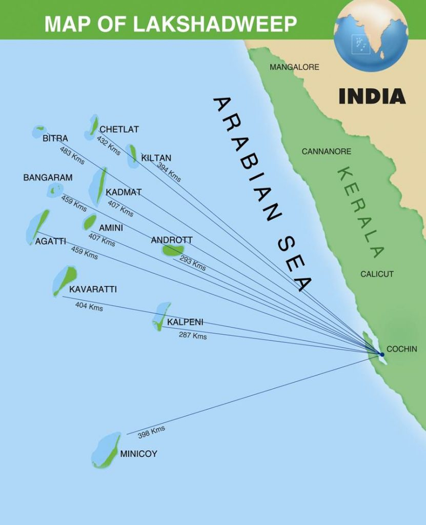
- India’s smallest Union Territory, Lakshadweep is an archipelago consisting of 36 islands with an area of 32 sq km.
- There are three main group of islands: Amindivi Islands, Laccadive Islands, Minicoy Island.
- All are tiny islands of coral origin (Atoll) and are surrounded by fringing reefs.
- The Capital is Kavaratti and it is also the principal town of the UT.
- These islands are a part of Reunion Hotspot volcanism.
- The entire Lakshadweep islands group is made up of coral deposits.
- Fishing is the main occupation on which livelihoods of many people depend.
- The Lakshadweep islands have storm beaches consisting of unconsolidated pebbles, shingles, cobbles, and boulders.
- Minicoy Island, located to the south of the nine-degree channel is the largest island among the Lakshadweep group.
- 8 Degree Channel (8 degrees north latitude) separates islands of Minicoy and Maldives.
- 9 Degree Channel (9 degrees north latitude) separates the island of Minicoy from the main Lakshadweep archipelago.
- In the Lakshadweep region, there is an absence of forests.
- Pitti Island is an important breeding place for sea turtles and for a number of pelagic birds such as the brown noddy, lesser crested tern and greater crested tern. The Pitti island has been declared a bird sanctuary.

Highlights of the study on rising sea levels
- The study highlights that the worst possible inundation scenarios projected for Lakshadweep Islands are almost similar under different emission scenarios projected and all the islands in the archipelago would be vulnerable to impact from sea-level rise.
- One of the major threats in the coming years is rising sea level and its significant impact on small islands and this is for the first time, that climate model projections were used to assess the potential areas of inundation over the archipelago of Lakshadweep Islands in the Arabian Sea.

Loss of Land expected in Lakshadweep
- The study estimated that smaller islands Chetlat and Amini are expected to have major land-loss.
- Projection mapping indicated that about 60%-70% of existing shoreline would experience land-loss in Amini and about 70%-80% in Chetlat.
- The present work highlights that, larger islands Minicoy and the capital Kavaratti are also vulnerable to sea-level rise, and expected to experience land-loss along 60% of the existing shoreline.
- Sea-level rise effects are seen to have the least impact on Androth Island under all emission scenarios.
Sea Level Rise
- Sea Level Rise is an increase in the level of the world’s oceans due to the effects of climate change, especially global warming, induced by three primary factors: Thermal Expansion, Melting Glaciers and Loss of Greenland and Antarctica’s ice sheets.
- Sea level is primarily measured using tide stations and satellite laser altimeters.
Factors leading to Sea Level Rise
- Thermal Expansion: When water heats up, it expands. About half of the sea-level rise over the past 25 years is attributable to warmer oceans simply occupying more space.
- Melting Glaciers: Higher temperatures caused by global warming have led to greater-than-average summer melting of large ice formations like mountain glaciers as well as diminished snowfall due to later winters and earlier springs. That creates an imbalance between runoff and ocean evaporation, causing sea levels to rise.
- Loss of Greenland and Antarctic Ice Sheets: As with mountain glaciers, increased heat is causing the massive ice sheets that cover Greenland and Antarctica to melt more quickly, and also move more quickly into the sea.
-Source: The Hindu


