Focus: GS-I Geography, GS-III Disaster Management
Why in news?
- At least 14 people were killed in Turkey and Greece after a strong earthquake struck the Aegean Sea in October 2020, bringing buildings crashing down and setting off tidal waves which slammed into coastal areas and islands.
- The Earthquake struck with a magnitude of up to 7.0.
Turkey and Earthquakes
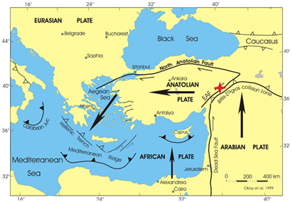
- Crisscrossed by major fault lines, Turkey is among the most earthquake-prone countries in the world.
- More than 17,000 people were killed in 1999 when a 7.6 magnitude quake struck Izmit, a city southeast of Istanbul.
- In 2011, a quake in the eastern city of Van killed more than 500.

Aegean Sea
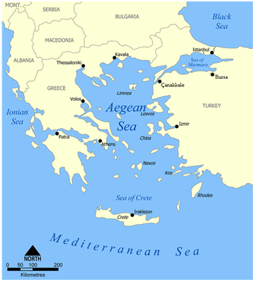
- The Aegean Sea is an elongated embayment of the Mediterranean Sea located between the Greek and Anatolian peninsulas.
- In the north, the Aegean is connected to the Marmara Sea and the Black Sea by the straits of the Dardanelles and the Bosphorus.
- The Aegean Islands are located within the sea and some bound it on its southern periphery, including Crete and Rhodes.
- The Thracian Sea and the Myrtoan Sea are subdivisions of the Aegean Sea.
- The Aegean Sea has been historically important, especially in regards to the civilization of Ancient Greece, who inhabited the area around the coast of the Aegean and the Aegean islands.
- The rocks making up the floor of the Aegean are mainly limestone, though often greatly altered by volcanic activity that has convulsed the region in relatively recent geologic times.

Earthquake
- An earthquake is shaking of the earth. It is a natural event. It is caused due to release of energy, which generates waves that travel in all directions.
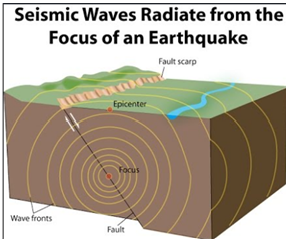
- The release of energy occurs along a fault. Rocks along a fault tend to move in opposite directions. This causes a release of energy, and the energy waves travel in all directions.
- The point where the energy is released is called the focus of an earthquake, alternatively, it is called the hypocentre.
- The point on the surface, nearest to the focus, is called epicentre. It is the first one to experience the waves. It is a point directly above the focus.

Earthquake Waves
All the natural earthquakes take place in the lithosphere.
Earthquake waves are basically of two types Body Waves and Surface Waves.
Body waves
- Body Waves are generated due to the release of energy at the focus and move in all directions travelling through the body of the earth.
- There are 2 types of body waves and they are, Primary waves [P] and Secondary [S] waves.
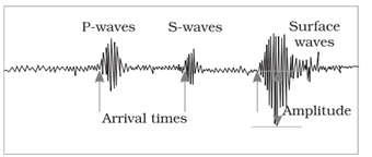
- Primary waves are the first to appear on the surface and hence the name P waves.
- P-waves vibrate parallel to the direction of the wave.
- This exerts pressure on the material in the direction of the propagation.
- P waves can travel through gaseous, liquid and solid materials.
- Secondary waves (S waves) appear after P waves.
- The direction of vibrations of S-waves is perpendicular to the wave direction in the vertical plane.
- Hence, they create troughs and crests in the material through which they pass.
Surface waves
- The body waves interact with the surface rocks and generate new set of waves called surface waves. These waves move along the surface.
- The velocity of waves changes as they travel through materials with different densities. The denser the material, the higher is the velocity.
- Their direction also changes as they reflect or refract when coming across materials with different densities.
- Surface waves are considered to be the most damaging waves.


Measurement of earthquakes
The earthquake events are scaled either according to the magnitude or intensity of the shock.
- Richter scale – The magnitude scale is known as the Richter scale. The magnitude relates to the energy released during the quake. The magnitude is expressed in absolute numbers, 0-10.
- Mercalli scale – The intensity scale is named after Mercalli, an Italian seismologist. The intensity scale takes into account the visible damage caused by the event. The range of intensity scale is from 1-12.
- Medvedev–Sponheuer–Karnik scale – This is a macroseismic intensity scale used to evaluate the severity of ground shaking on the basis of observed effects in an area of the earthquake occurrence.
-Source: The Hindu, Hindustan Times


