The Jan4th Static Quiz on Geography (Glacial Landforms)
Quiz-summary
0 of 10 questions completed
Questions:
- 1
- 2
- 3
- 4
- 5
- 6
- 7
- 8
- 9
- 10
Information
The Jan4th Static Quiz on Geography (Glacial Landforms)
You have already completed the quiz before. Hence you can not start it again.
Quiz is loading...
You must sign in or sign up to start the quiz.
You have to finish following quiz, to start this quiz:
Results
0 of 10 questions answered correctly
Your time:
Time has elapsed
You have reached 0 of 0 points, (0)
Categories
- Not categorized 0%
- 1
- 2
- 3
- 4
- 5
- 6
- 7
- 8
- 9
- 10
- Answered
- Review
- Question 1 of 10
1. Question
Which of the following are the Glacial Erosional Landforms?
1. Hanging Valley
2. Cirques
3. EskersCorrectAns;- a) Only 1 and 2
Explanation;-
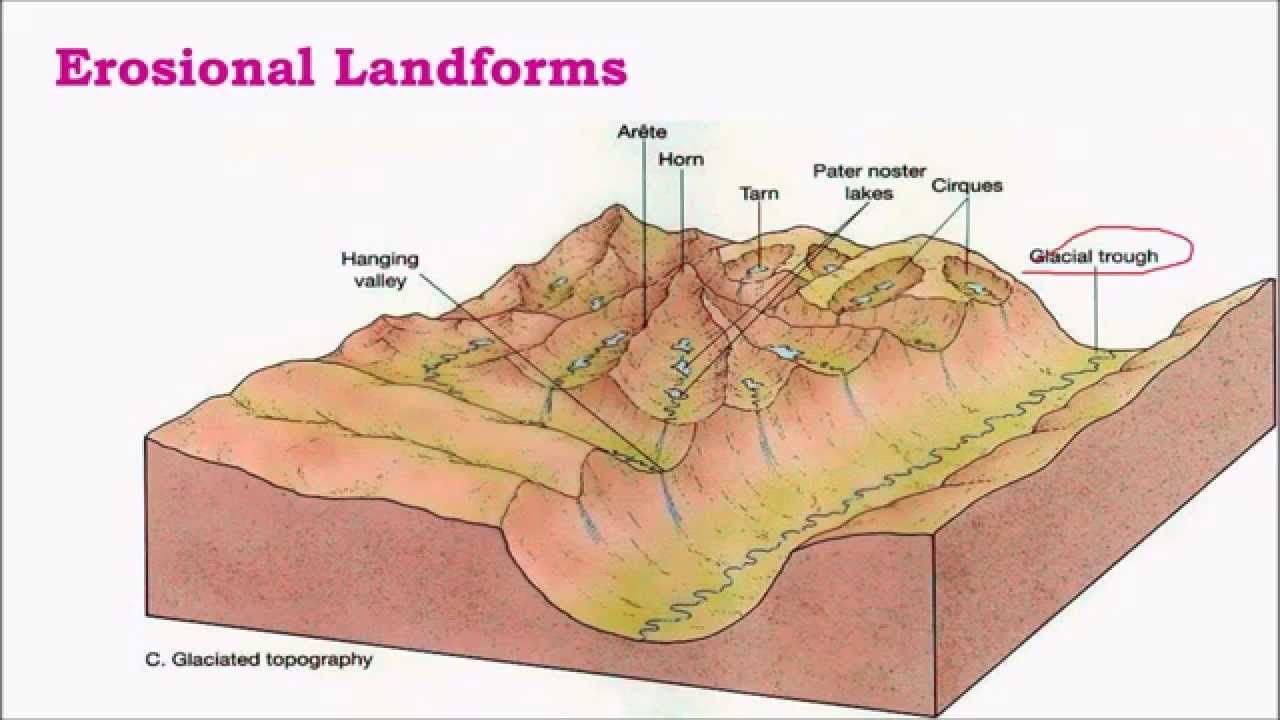
• The 3rd is the depositional landforms of Glacier not erosional.
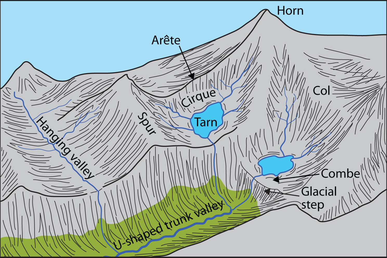
• A hanging valley is a tributary valley that is higher than the main valley.
• They are most commonly associated with U-shaped valleys when a tributary glacier flows into a glacier of larger volume.
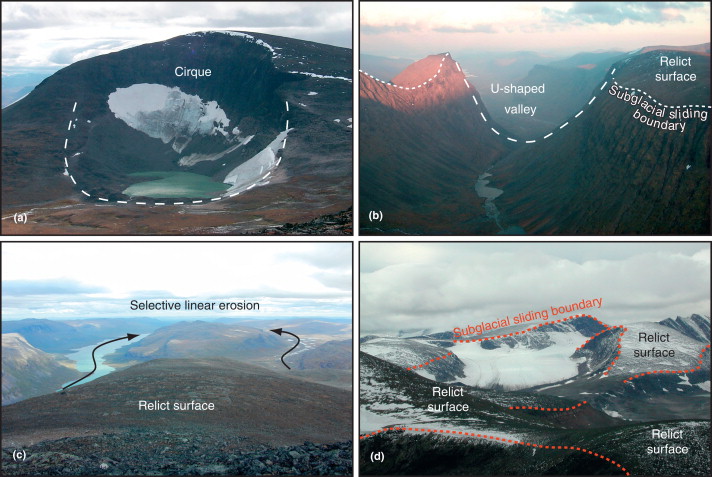
• A cirque glacier is formed in a cirque, a bowl-shaped depression on the side of or near mountains. Snow and ice accumulation in corries often occurs as the result of avalanching from higher surrounding slopes. If a cirque glacier advances far enough, it may become a valley glacier.

• Eskers are ridges made of sands and gravels, deposited by glacial meltwater flowing through tunnels within and underneath glaciers, or through meltwater channels on top of glaciers. Over time, the channel or tunnel gets filled up with sediments.
 Incorrect
Ans;- a) Only 1 and 2
Explanation;-
• The 3rd is the depositional landforms of Glacier not erosional.
• A hanging valley is a tributary valley that is higher than the main valley.
• They are most commonly associated with U-shaped valleys when a tributary glacier flows into a glacier of larger volume.
• A cirque glacier is formed in a cirque, a bowl-shaped depression on the side of or near mountains. Snow and ice accumulation in corries often occurs as the result of avalanching from higher surrounding slopes. If a cirque glacier advances far enough, it may become a valley glacier.

• Eskers are ridges made of sands and gravels, deposited by glacial meltwater flowing through tunnels within and underneath glaciers, or through meltwater channels on top of glaciers. Over time, the channel or tunnel gets filled up with sediments.

- Question 2 of 10
2. Question
Which of the following are the Glacial Depositional Landforms?
1. Drumlin Filed
2. Cirques
3. AreteCorrectAns;- a) Only 1
Explanation;-
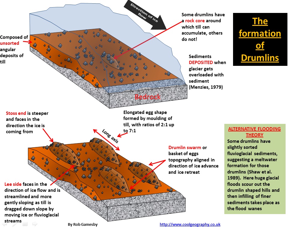
• The 2nd and 3rd are Erosional Features of Glacier.• Drumlins are elongated, teardrop-shaped hills of rock, sand, and gravel that formed under moving glacier ice. They can be up to 2 kilometers (1.25 miles) long.
• Erosion under a glacier in the immediate vicinity of a drumlin can be on the order of a meter’s depth of sediment per year, depending heavily on the shear stress acting on the ground below the glacier from the weight of the glacier itself, with the eroded sediment forming a drumlin as it is repositioned and deposited.
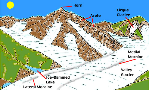
• An arête is a thin, crest of rock left after two adjacent glaciers have worn a steep ridge into the rock. A horn results when glaciers erode three or more arêtes, usually forming a sharp-edged peak. Cirques are concave, circular basins carved by the base of a glacier as it erodes the landscape.
 Incorrect
Ans;- a) Only 1
Explanation;-
• The 2nd and 3rd are Erosional Features of Glacier.• Drumlins are elongated, teardrop-shaped hills of rock, sand, and gravel that formed under moving glacier ice. They can be up to 2 kilometers (1.25 miles) long.
• Erosion under a glacier in the immediate vicinity of a drumlin can be on the order of a meter’s depth of sediment per year, depending heavily on the shear stress acting on the ground below the glacier from the weight of the glacier itself, with the eroded sediment forming a drumlin as it is repositioned and deposited.
• An arête is a thin, crest of rock left after two adjacent glaciers have worn a steep ridge into the rock. A horn results when glaciers erode three or more arêtes, usually forming a sharp-edged peak. Cirques are concave, circular basins carved by the base of a glacier as it erodes the landscape.

- Question 3 of 10
3. Question
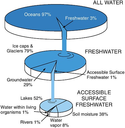
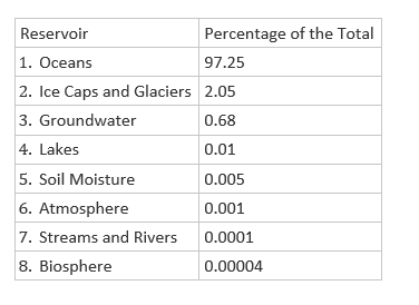
On the planet earth, most of the freshwater exists as ice caps and glaciers. Out of the remaining freshwater, the largest proportion
Correct
 Incorrect

- Question 4 of 10
4. Question
Which of the following statements are correct regarding Glacial Cycle of Erosion?
1. In Youth stage is marked by the inward cutting activity of ice in a cirque.
2. In Maturity Hanging valleys start emerging.
3. Emergence of a ‘U’-shaped valley marks the beginning of old age.CorrectAns;- d) All of the above
Explanation;-
• All the statements are correct.About Glacial Cycle of Erosion
• Youth
• The stage is marked by the inward cutting activity of ice in a cirque.
• Aretes and horns are emerging. The hanging valleys are not prominent at this stage.
• Maturity
• Hanging valleys start emerging. The opposite cirques come closer and the glacial trough acquires a stepped profile which is regular and graded.
• Old Age
• Emergence of a ‘U’-shaped valley marks the beginning of old age.
• An outwash plain with features such as eskers, kame terraces, drumlins, kettle holes etc. is a prominent development.IncorrectAns;- d) All of the above
Explanation;-
• All the statements are correct.About Glacial Cycle of Erosion
• Youth
• The stage is marked by the inward cutting activity of ice in a cirque.
• Aretes and horns are emerging. The hanging valleys are not prominent at this stage.
• Maturity
• Hanging valleys start emerging. The opposite cirques come closer and the glacial trough acquires a stepped profile which is regular and graded.
• Old Age
• Emergence of a ‘U’-shaped valley marks the beginning of old age.
• An outwash plain with features such as eskers, kame terraces, drumlins, kettle holes etc. is a prominent development. - Question 5 of 10
5. Question
Which of the following regarding D-Fjord are correct?
1. Steep-sided narrow entrance-like feature at the coast where the stream meets the coast.
2. Fjords are common in Norway, Greenland and New Zealand.CorrectAns;- c) Both 1 and 2
Explanation;-
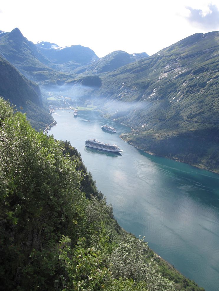
• Both the statements are correct.• A fjord is a long, deep, narrow body of water that reaches far inland. Fjords are often set in a U-shaped valley with steep walls of rock on either side. Fjords are found mainly in Norway, Chile, New Zealand, Canada, Greenland, and the U.S. state of Alaska.
• A true fjord is formed when a glacier cuts a U-shaped valley by ice segregation and abrasion of the surrounding bedrock.
• Glacial melting is accompanied by the rebounding of Earth’s crust as the ice load and eroded sediment is removed (also called isostasy or glacial rebound).
• Glacial erosion produces U-shaped valleys, and fjords are characteristically so shaped.
• This rise can cause some fjords to have very strong currents or even saltwater rapids. Another dangerous feature found near some fjords is the presence of thousands of small, rocky island blocks. These areas are called skerries and they can be treacherous for ships to navigate. Incorrect
Ans;- c) Both 1 and 2
Explanation;-
• Both the statements are correct.• A fjord is a long, deep, narrow body of water that reaches far inland. Fjords are often set in a U-shaped valley with steep walls of rock on either side. Fjords are found mainly in Norway, Chile, New Zealand, Canada, Greenland, and the U.S. state of Alaska.
• A true fjord is formed when a glacier cuts a U-shaped valley by ice segregation and abrasion of the surrounding bedrock.
• Glacial melting is accompanied by the rebounding of Earth’s crust as the ice load and eroded sediment is removed (also called isostasy or glacial rebound).
• Glacial erosion produces U-shaped valleys, and fjords are characteristically so shaped.
• This rise can cause some fjords to have very strong currents or even saltwater rapids. Another dangerous feature found near some fjords is the presence of thousands of small, rocky island blocks. These areas are called skerries and they can be treacherous for ships to navigate.
- Question 6 of 10
6. Question
Which of the following regarding Outwash Plain are correct?
1. When the glacier reaches its lowest point and melts, it leaves behind a stratified deposition material, consisting of rock debris, clay, sand, gravel etc. This layered surface is called till plain or an outwash plain.
2. They are composed of glacial sediments that have been reworked by flowing water.CorrectAns;- c) Both 1 and 2
Explanation;-
• Both the statements are correct regarding Outwash Plain are correct.About Outwash Plain
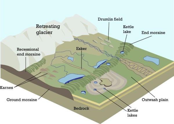
• When the glacier reaches its lowest point and melts, it leaves behind a stratified deposition material, consisting of rock debris, clay, sand, gravel etc. This layered surface is called till plain or an outwash plain.
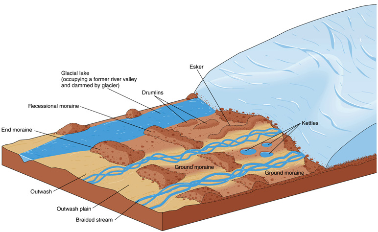
• An outwash plain, also called a sandur, sandr or sandar, is a plain formed of glacial sediments deposited by meltwater outwash at the terminus of a glacier. As it flows, the glacier grinds the underlying rock surface and carries the debris along.
• Outwash plains and eskers form due to the flow of meltwater in front of (outwash plains) or beneath (eskers) that glacier ice. They are composed of glacial sediments that have been reworked by flowing water.
• An outwash plain is both an erosional and depositional surface created by meltwater coming from the glacier. These plains are found in front of the glaciers and are typically characterized by small braided streams. Incorrect
Ans;- c) Both 1 and 2
Explanation;-
• Both the statements are correct regarding Outwash Plain are correct.About Outwash Plain
• When the glacier reaches its lowest point and melts, it leaves behind a stratified deposition material, consisting of rock debris, clay, sand, gravel etc. This layered surface is called till plain or an outwash plain.
• An outwash plain, also called a sandur, sandr or sandar, is a plain formed of glacial sediments deposited by meltwater outwash at the terminus of a glacier. As it flows, the glacier grinds the underlying rock surface and carries the debris along.
• Outwash plains and eskers form due to the flow of meltwater in front of (outwash plains) or beneath (eskers) that glacier ice. They are composed of glacial sediments that have been reworked by flowing water.
• An outwash plain is both an erosional and depositional surface created by meltwater coming from the glacier. These plains are found in front of the glaciers and are typically characterized by small braided streams.
- Question 7 of 10
7. Question
Which of the following regarding Glacial Moraine are incorrect?
1. A moraine is material left behind by a moving glacier.
2. Moraines may be composed of debris ranging in size from silt-sized glacial flour to large boulders.CorrectAns;- d) None of the above
Explanation;-
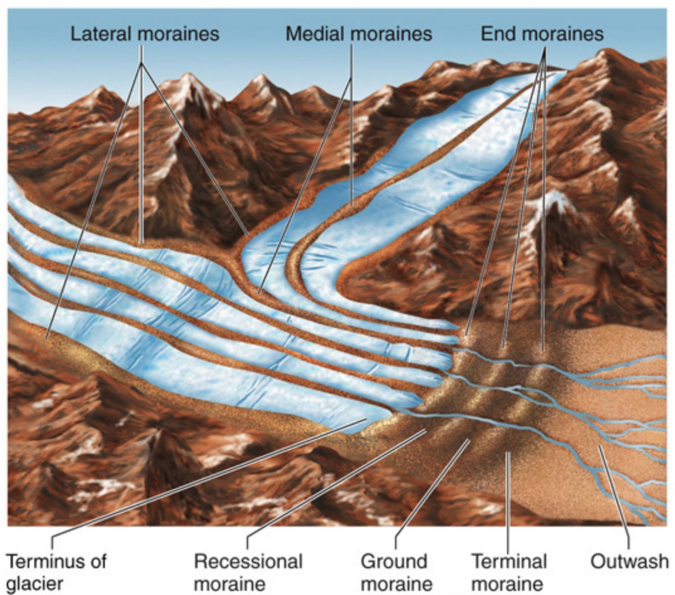
• As question asked to choose incorrect statement but both the statements are correct that’s y answer is D• A moraine is any accumulation of unconsolidated debris, sometimes referred to as glacial till, that occurs in both currently and formerly glaciated regions, and that has been previously carried along by a glacier or ice sheet.
• A moraine is material left behind by a moving glacier. This material is usually soil and rock. Just as rivers carry along all sorts of debris and silt that eventually builds up to form deltas, glaciers transport all sorts of dirt and boulders that build up to form moraines.
• Most commonly “moraine” is used to describe ridge-shaped glacial landforms, i.e., moraine ridges, although the term also covers landforms of large spatial extent, such as subglacial till plains (ground moraines) and hummocky moraines formed by melt-out of large areas of stagnant, debris-covered glacier ice.
• Characteristics. Moraines may be composed of debris ranging in size from silt-sized glacial flour to large boulders. The debris is typically sub-angular to rounded in shape. Moraines may be on the glacier’s surface or deposited as piles or sheets of debris where the glacier has melted. Incorrect
Ans;- d) None of the above
Explanation;-
• As question asked to choose incorrect statement but both the statements are correct that’s y answer is D• A moraine is any accumulation of unconsolidated debris, sometimes referred to as glacial till, that occurs in both currently and formerly glaciated regions, and that has been previously carried along by a glacier or ice sheet.
• A moraine is material left behind by a moving glacier. This material is usually soil and rock. Just as rivers carry along all sorts of debris and silt that eventually builds up to form deltas, glaciers transport all sorts of dirt and boulders that build up to form moraines.
• Most commonly “moraine” is used to describe ridge-shaped glacial landforms, i.e., moraine ridges, although the term also covers landforms of large spatial extent, such as subglacial till plains (ground moraines) and hummocky moraines formed by melt-out of large areas of stagnant, debris-covered glacier ice.
• Characteristics. Moraines may be composed of debris ranging in size from silt-sized glacial flour to large boulders. The debris is typically sub-angular to rounded in shape. Moraines may be on the glacier’s surface or deposited as piles or sheets of debris where the glacier has melted.
- Question 8 of 10
8. Question
Which of the following statements regarding Cirque/Corrie are correct?
1. Hollow basin cut into a mountain ridge.
2. When the ice melts, the cirque may develop into a tarn lake.CorrectAns;- c) Both 1 and 2
Explanation;-
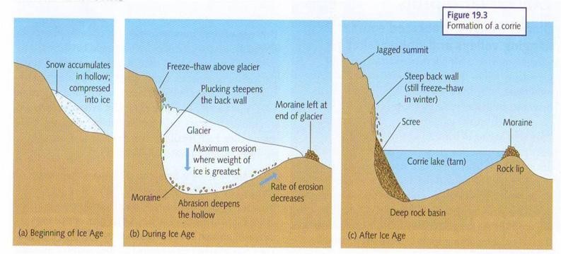
• Both the staements are correct about Cirque/Corrie• A cirque is an amphitheatre-like valley formed by glacial erosion. Alternative names for this landform are corrie and cwm. A cirque may also be a similarly shaped landform arising from fluvial erosion.
• The concave shape of a glacial cirque is open on the downhill side, while the cupped section is generally steep.
Corries form in hollows where snow can accumulate.
• The snow compacts into ice and this accumulates over many years to compact and grow into a corrie/cirque glacier.
• This then moves down hill because of gravity and the mass of the ice. Incorrect
Ans;- c) Both 1 and 2
Explanation;-
• Both the staements are correct about Cirque/Corrie• A cirque is an amphitheatre-like valley formed by glacial erosion. Alternative names for this landform are corrie and cwm. A cirque may also be a similarly shaped landform arising from fluvial erosion.
• The concave shape of a glacial cirque is open on the downhill side, while the cupped section is generally steep.
Corries form in hollows where snow can accumulate.
• The snow compacts into ice and this accumulates over many years to compact and grow into a corrie/cirque glacier.
• This then moves down hill because of gravity and the mass of the ice.
- Question 9 of 10
9. Question
Which of the following landforms created by glacial erosion?
CorrectAns;- d) All of the above
Explanation:-
• As a glacier moves over the land, it drags rock fragments, gravel and sand along with it.
• These rock fragments become efficient erosive tools.
• With their help glacier scrapes and scours the surface rocks with which it comes in contact. This action of glacier leaves behind scratches and grooves on rocks.
• The landforms like Cirque, ‘U’ shaped valley, Hanging Valley etc are created by the glacial erosion. Incorrect
Ans;- d) All of the above
Explanation:-
• As a glacier moves over the land, it drags rock fragments, gravel and sand along with it.
• These rock fragments become efficient erosive tools.
• With their help glacier scrapes and scours the surface rocks with which it comes in contact. This action of glacier leaves behind scratches and grooves on rocks.
• The landforms like Cirque, ‘U’ shaped valley, Hanging Valley etc are created by the glacial erosion.
- Question 10 of 10
10. Question
Consider the following statements regarding the Hanging Valley are correct?
1. Formed when smaller tributaries are unable to cut as deeply as bigger ones and remain ‘hanging’ at higher levels than the main valley as discordant tributaries.
2. A valley carved out by a small tributary glacier that joins with a valley carved out by a much larger glacier.CorrectAns;- c) Both 1 and 2
Explanation;-
• Both the statements are correct.• A hanging valley is a tributary valley that is higher than the main valley. They are most commonly associated with U-shaped valleys when a tributary glacier flows into a glacier of larger volume.
• Just like tributary streams of the river, there are tributary the glaciers also which join the main glacier after moving over their mountainous path.
• These tributary glaciers like the main glaciers carve U – shaped valleys.
• However, they have less volume of ice than the main glaciers and thus their rate of erosion is less rapid.
• As a result, their valleys are smaller and not as deep as that of the main glacier.
• Due to this difference in deepening; the valley of the tributary glacier is left at a higher level than that of the main glacier.
• The val1ey of the tributary glacier just looks like hanging downwards at the point of its confluence with the main valley.
• This type of a topographical feature is cal1ed a hanging val1ey.
• This feature is visible when ice has melted in both the val1eys.
• When the ice in the hanging valley melts, a waterfall is formed at the point of confluence of this stream with the main river. Incorrect
Ans;- c) Both 1 and 2
Explanation;-
• Both the statements are correct.• A hanging valley is a tributary valley that is higher than the main valley. They are most commonly associated with U-shaped valleys when a tributary glacier flows into a glacier of larger volume.
• Just like tributary streams of the river, there are tributary the glaciers also which join the main glacier after moving over their mountainous path.
• These tributary glaciers like the main glaciers carve U – shaped valleys.
• However, they have less volume of ice than the main glaciers and thus their rate of erosion is less rapid.
• As a result, their valleys are smaller and not as deep as that of the main glacier.
• Due to this difference in deepening; the valley of the tributary glacier is left at a higher level than that of the main glacier.
• The val1ey of the tributary glacier just looks like hanging downwards at the point of its confluence with the main valley.
• This type of a topographical feature is cal1ed a hanging val1ey.
• This feature is visible when ice has melted in both the val1eys.
• When the ice in the hanging valley melts, a waterfall is formed at the point of confluence of this stream with the main river.

