The Dec 24th Static Quiz on Geography Landforms (Rivers)
Quiz-summary
0 of 10 questions completed
Questions:
- 1
- 2
- 3
- 4
- 5
- 6
- 7
- 8
- 9
- 10
Information
The Dec 24th Static Quiz on Geography Landforms (Rivers)
You have already completed the quiz before. Hence you can not start it again.
Quiz is loading...
You must sign in or sign up to start the quiz.
You have to finish following quiz, to start this quiz:
Results
0 of 10 questions answered correctly
Your time:
Time has elapsed
You have reached 0 of 0 points, (0)
Categories
- Not categorized 0%
- 1
- 2
- 3
- 4
- 5
- 6
- 7
- 8
- 9
- 10
- Answered
- Review
- Question 1 of 10
1. Question
Which of the following erosional features of rivers?
1. V-Shaped Valley
2. Interlocking Spurs
3. Deltas
4. Ox-Bow LakesCorrectAns;- c) Only 1,2 and 4
Explanation;-
• Except the Deltas all are the Erosional Features created By Rivers, Deltas are the Depositional Features of Rivers, even the Ox-bow has both the deposition and erosion but more appropriate option will be C ,because Delta is absolutely a depositional feature of river.
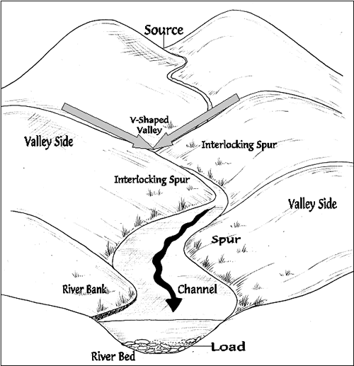
• A V-valley is formed by erosion from a river or stream over time. It is called a V-valley as the shape of the valley is the same as the letter “V”.
• As the river erodes downwards the sides of the valley are exposed to freeze-thaw weathering which loosens the rocks (some of which will fall into the river) and steepens the valley sides.
• An interlocking spur, also known as an overlapping spur, is one of any number of projecting ridges that extend alternately from the opposite sides of the wall of a young, V-shaped valley down which a river with a winding course flows.

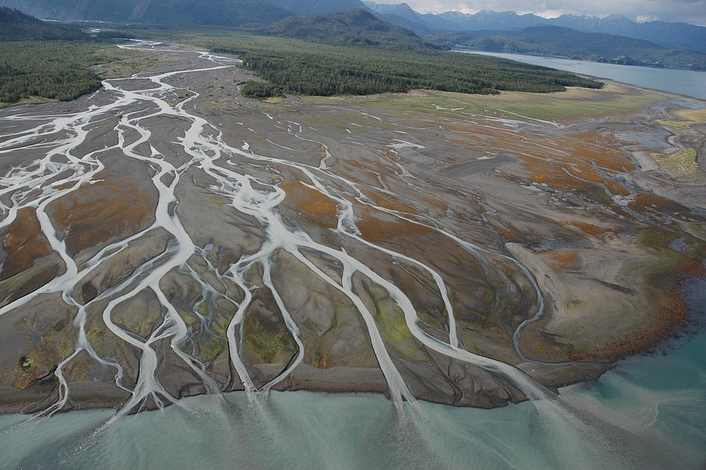
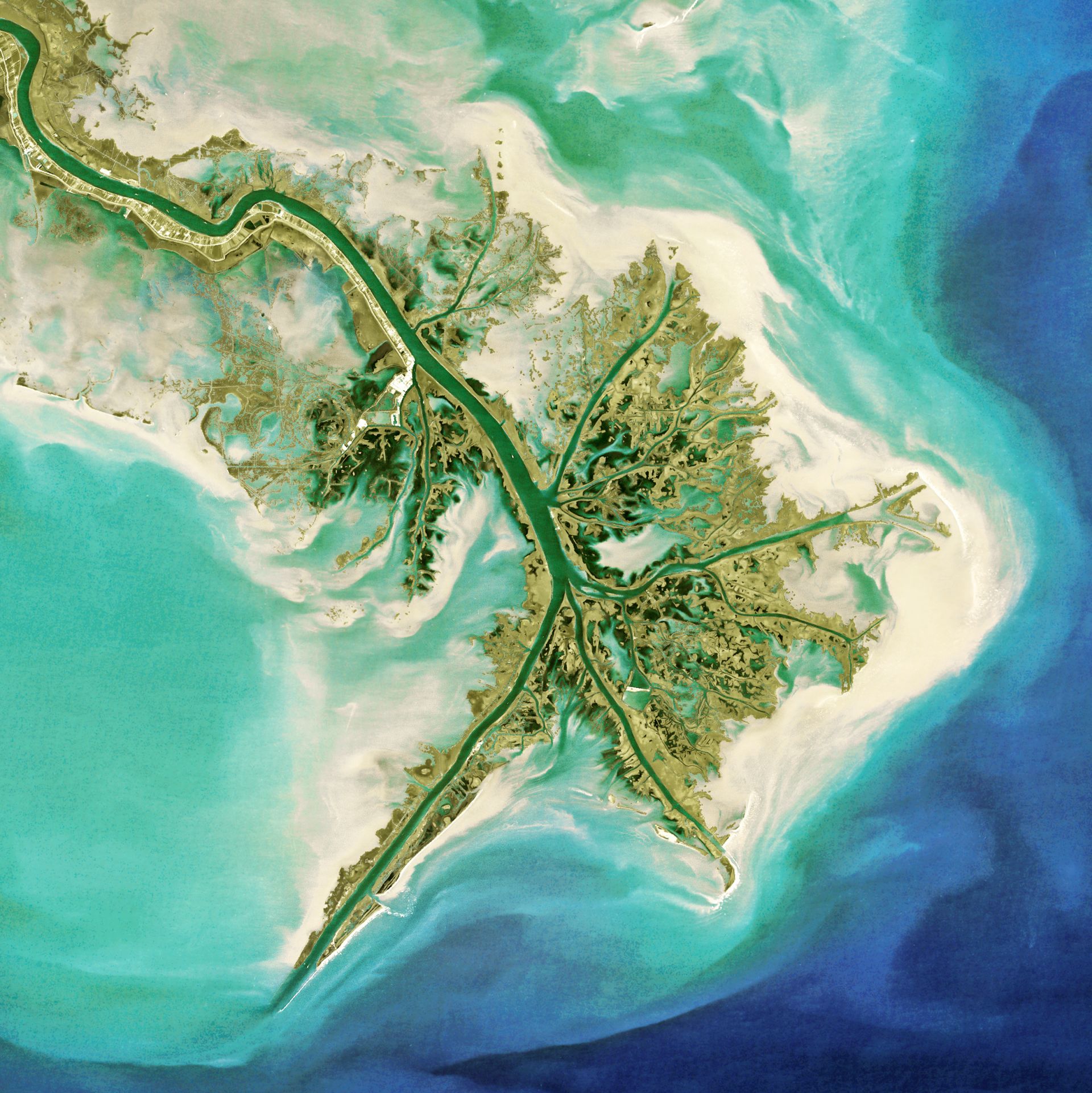
• A river delta is a landform created by deposition of sediment that is carried by a river as the flow leaves its mouth and enters slower-moving or stagnant water.
• This occurs where a river enters an ocean, sea, estuary, lake, reservoir, or (more rarely) another river that cannot carry away the supplied sediment.
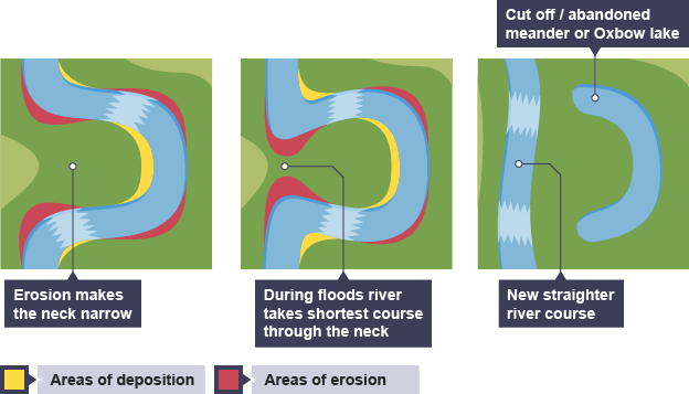
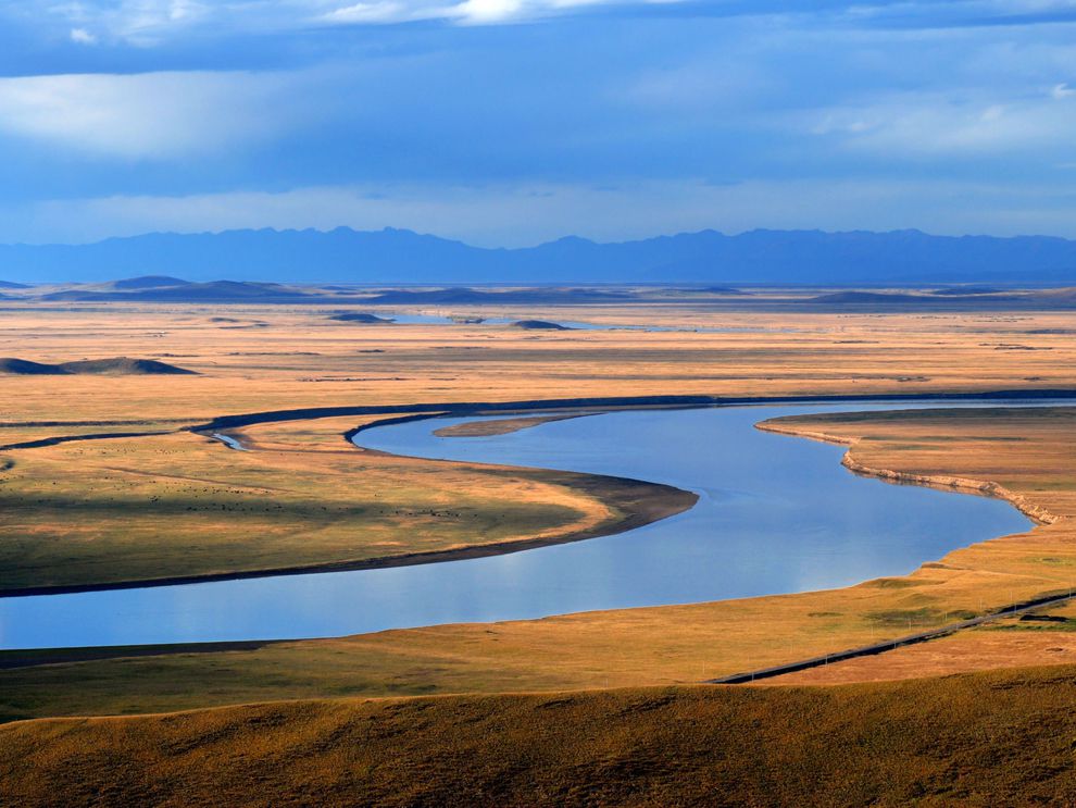
• Sometimes, because of intensive erosion action, the outer curve of a meander gets accentuated to such an extent that the inner ends of the loop come close enough to get disconnected from the main channel and exist as independent water bodies called as oxbow lakes.
• These water bodies are converted into swamps in due course of time. Incorrect
Ans;- c) Only 1,2 and 4
Explanation;-
• Except the Deltas all are the Erosional Features created By Rivers, Deltas are the Depositional Features of Rivers, even the Ox-bow has both the deposition and erosion but more appropriate option will be C ,because Delta is absolutely a depositional feature of river.
• A V-valley is formed by erosion from a river or stream over time. It is called a V-valley as the shape of the valley is the same as the letter “V”.
• As the river erodes downwards the sides of the valley are exposed to freeze-thaw weathering which loosens the rocks (some of which will fall into the river) and steepens the valley sides.
• An interlocking spur, also known as an overlapping spur, is one of any number of projecting ridges that extend alternately from the opposite sides of the wall of a young, V-shaped valley down which a river with a winding course flows.

• A river delta is a landform created by deposition of sediment that is carried by a river as the flow leaves its mouth and enters slower-moving or stagnant water.
• This occurs where a river enters an ocean, sea, estuary, lake, reservoir, or (more rarely) another river that cannot carry away the supplied sediment.
• Sometimes, because of intensive erosion action, the outer curve of a meander gets accentuated to such an extent that the inner ends of the loop come close enough to get disconnected from the main channel and exist as independent water bodies called as oxbow lakes.
• These water bodies are converted into swamps in due course of time.
- Question 2 of 10
2. Question
Which of the following depositional features of rivers?
1. Alluvial Fans
2. Flood Plains
3. Deltas
4. Natural LeveeCorrectAns;- d) All of the above
Explanation;-
• All are the depositional features of rivers.
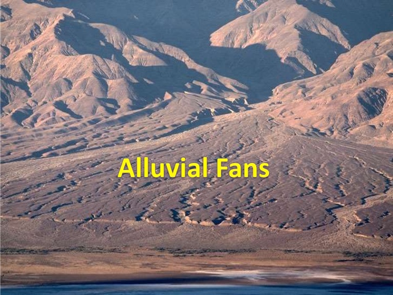
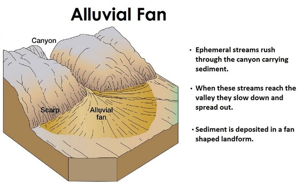
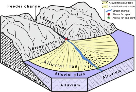
• An alluvial fan is an accumulation of sediments shaped like a section of a shallow cone, with its apex at a point source of sediments, such as a narrow canyon emerging from an escarpment.

• A floodplain or flood plain or flood-plain is an area of land adjacent to a stream or river which stretches from the banks of its channel to the base of the enclosing valley walls, and which experiences flooding during periods of high discharge.

• Deltas are wetlands that form as rivers empty their water and sediment into another body of water, such as an ocean, lake, or another river. Although very uncommon, deltas can also empty into land. A river moves more slowly as it nears its mouth, or end.

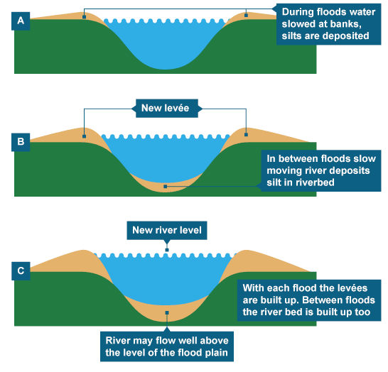
• A natural levee has a long, broad, low shape and is composed of sand and coarse silt, which was built by a stream on its flood plain and along both sides of its channel especially in time of flood when water overflowing the normal banks is forced to deposit the coarsest part of its load.
 Incorrect
Ans;- d) All of the above
Explanation;-
• All are the depositional features of rivers.
• An alluvial fan is an accumulation of sediments shaped like a section of a shallow cone, with its apex at a point source of sediments, such as a narrow canyon emerging from an escarpment.

• A floodplain or flood plain or flood-plain is an area of land adjacent to a stream or river which stretches from the banks of its channel to the base of the enclosing valley walls, and which experiences flooding during periods of high discharge.

• Deltas are wetlands that form as rivers empty their water and sediment into another body of water, such as an ocean, lake, or another river. Although very uncommon, deltas can also empty into land. A river moves more slowly as it nears its mouth, or end.

• A natural levee has a long, broad, low shape and is composed of sand and coarse silt, which was built by a stream on its flood plain and along both sides of its channel especially in time of flood when water overflowing the normal banks is forced to deposit the coarsest part of its load.

- Question 3 of 10
3. Question
Which of the following landforms is a Fluvial Landforms?
CorrectAns;- d) Ait
Explanation;-
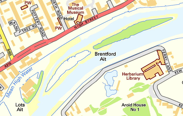
• Ait is the Fluvial landform, remaining are not.
• Fluvial landforms are those generated by running water, mainly rivers. The term fluvial derives from the Latin word fluvius that means river.
• An ait is a small island. It is especially used to refer to river islands found on the River Thames and its tributaries in England.
• Aits are typically formed by the deposit of sediment in the water, which accumulates over a period of time.

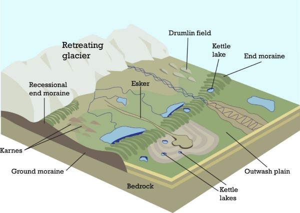
• An esker, eskar, eschar, or os, sometimes called an asar, osar, or serpent kame, is a long, winding ridge of stratified sand and gravel, examples of which occur in glaciated and formerly glaciated regions of Europe and North America.

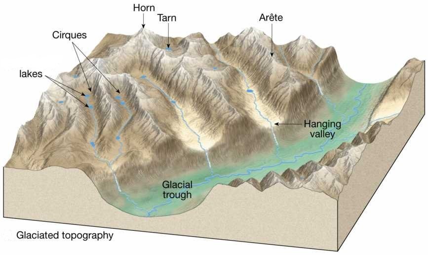
• A cirque is an amphitheatre-like valley formed by glacial erosion. Alternative names for this landform are corrie and cwm. A cirque may also be a similarly shaped landform arising from fluvial erosion. The concave shape of a glacial cirque is open on the downhill side, while the cupped section is generally steep.

• An arête is a thin, crest of rock left after two adjacent glaciers have worn a steep ridge into the rock. A horn results when glaciers erode three or more arêtes, usually forming a sharp-edged peak. Cirques are concave, circular basins carved by the base of a glacier as it erodes the landscape.
IncorrectAns;- d) Ait
Explanation;-
• Ait is the Fluvial landform, remaining are not.
• Fluvial landforms are those generated by running water, mainly rivers. The term fluvial derives from the Latin word fluvius that means river.
• An ait is a small island. It is especially used to refer to river islands found on the River Thames and its tributaries in England.
• Aits are typically formed by the deposit of sediment in the water, which accumulates over a period of time.

• An esker, eskar, eschar, or os, sometimes called an asar, osar, or serpent kame, is a long, winding ridge of stratified sand and gravel, examples of which occur in glaciated and formerly glaciated regions of Europe and North America.

• A cirque is an amphitheatre-like valley formed by glacial erosion. Alternative names for this landform are corrie and cwm. A cirque may also be a similarly shaped landform arising from fluvial erosion. The concave shape of a glacial cirque is open on the downhill side, while the cupped section is generally steep.

• An arête is a thin, crest of rock left after two adjacent glaciers have worn a steep ridge into the rock. A horn results when glaciers erode three or more arêtes, usually forming a sharp-edged peak. Cirques are concave, circular basins carved by the base of a glacier as it erodes the landscape.
- Question 4 of 10
4. Question
Which of the following Triangular deposition of Fluvial Landforms are called?
CorrectAns;- c) Alluvial Fans
Explanation;-
• An alluvial fan is a triangle-shaped deposit of gravel, sand, and even smaller pieces of sediment, such as silt, this sediment is called alluvium.
• Alluvial fans are usually created as flowing water interacts with mountains, hills, or the steep walls of canyons.
• Alluvial fans and bajadas are often found in deserts, where flash floods wash alluvium down from nearby hills.
• They can also be found in wetter climates, where streams are more common. Alluvial fans are even found underwater.
• Both deltas and alluvial fans are types of depositional land forms formed by flowing rivers.
• Alluvial fans are formed at foothills where streams flowing from higher level break into foot slope plains of low gradient whereas deltas are formed near mouth of streams where it meets seas or stagnant water bodies. Incorrect
Ans;- c) Alluvial Fans
Explanation;-
• An alluvial fan is a triangle-shaped deposit of gravel, sand, and even smaller pieces of sediment, such as silt, this sediment is called alluvium.
• Alluvial fans are usually created as flowing water interacts with mountains, hills, or the steep walls of canyons.
• Alluvial fans and bajadas are often found in deserts, where flash floods wash alluvium down from nearby hills.
• They can also be found in wetter climates, where streams are more common. Alluvial fans are even found underwater.
• Both deltas and alluvial fans are types of depositional land forms formed by flowing rivers.
• Alluvial fans are formed at foothills where streams flowing from higher level break into foot slope plains of low gradient whereas deltas are formed near mouth of streams where it meets seas or stagnant water bodies.
- Question 5 of 10
5. Question
Which of the following are correctly matched?
1. Attrition= this is the chemical or solvent action of water on soluble or partly-soluble rocks with which the river comes into contact.
2. Corrosion= It is a mechanical process, in which the moving water current flows against the banks and bed of a river, thereby removing rock particles.
3. Hydraulic action = this is a form of fluvial erosion in which the bed load is eroded by itself due to wear and tear of the transported material when they roll and collide into one another.CorrectAns;- d) None of the above
Explanation;-
• All are incorrectly matched.
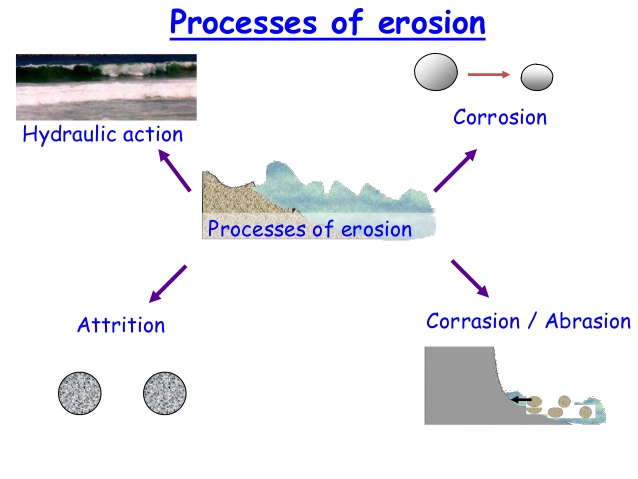
• Hydraulic action It is a mechanical process, in which the moving water current flows against the banks and bed of a river, thereby removing rock particles.
• Some of the water splashes against the river banks and surges into cracks and crevices. This helps to disintegrate the rocks. The river water picks up the loose fragments from its banks and bed and transports them away.• Attrition this is a form of fluvial erosion in which the bed load is eroded by itself due to wear and tear of the transported material when they roll and collide into one another. The coarser boulders are broken down into smaller stones and pebbles.
• Corrosion or solution this is the chemical or solvent action of water on soluble or partly-soluble rocks with which the river comes into contact. For example, calcium carbonate in limestone is easily dissolved and removed in solution.
 Incorrect
Ans;- d) None of the above
Explanation;-
• All are incorrectly matched.
• Hydraulic action It is a mechanical process, in which the moving water current flows against the banks and bed of a river, thereby removing rock particles.
• Some of the water splashes against the river banks and surges into cracks and crevices. This helps to disintegrate the rocks. The river water picks up the loose fragments from its banks and bed and transports them away.• Attrition this is a form of fluvial erosion in which the bed load is eroded by itself due to wear and tear of the transported material when they roll and collide into one another. The coarser boulders are broken down into smaller stones and pebbles.
• Corrosion or solution this is the chemical or solvent action of water on soluble or partly-soluble rocks with which the river comes into contact. For example, calcium carbonate in limestone is easily dissolved and removed in solution.

- Question 6 of 10
6. Question
Which among the following statements is/are correct about alluvial fans?
1. They are triangular-shaped deposits of water-transported material.
2. The deposits are usually poorly sorted.
3. They are unconsolidated sedimentary deposits and tend to be larger and more prominent in arid to semi-arid regions.
4. The alluvial fans are the erosional feature of fluvial landformsCorrectAns;- a) Only 1,2 and 3
Explanation;-
• Except 4th staement all are correct because Alluvial Fans are depositional Landforms of River not Erosional.
• An alluvial fan is a cone-shaped depositional landform built up by streams, heavy with sediment load.
• Alluvial fans are formed when streams flowing from mountains break into foot slope plains of low gradient.
• Normally very coarse load is carried by streams flowing over mountain slopes. This load gets dumped as it becomes too heavy to be carried over gentler gradients by the streams
• Furthermore, this load spreads as a broad low to a high cone-shaped deposit called an alluvial fan that appears as a series of continuous fans.
• Alluvial fans in humid areas show normally low cones with a gentle slope from head to toe and they appear as high cones with a steep slope in arid and semi-arid climates. Incorrect
Ans;- a) Only 1,2 and 3
Explanation;-
• Except 4th staement all are correct because Alluvial Fans are depositional Landforms of River not Erosional.
• An alluvial fan is a cone-shaped depositional landform built up by streams, heavy with sediment load.
• Alluvial fans are formed when streams flowing from mountains break into foot slope plains of low gradient.
• Normally very coarse load is carried by streams flowing over mountain slopes. This load gets dumped as it becomes too heavy to be carried over gentler gradients by the streams
• Furthermore, this load spreads as a broad low to a high cone-shaped deposit called an alluvial fan that appears as a series of continuous fans.
• Alluvial fans in humid areas show normally low cones with a gentle slope from head to toe and they appear as high cones with a steep slope in arid and semi-arid climates.
- Question 7 of 10
7. Question
Which of the following are correctly matched?
1. Vertical Erosion = it is a process by which a river increases its upstream length.
2. Headwards Erosion = it is a process through which river channel is extended in its width
3. Lateral Erosion= takes place at the base of the river.CorrectAns;- d) None of the above
Explanation;-
• All are incorrectly matched.
• River erosion takes place in three ways:-
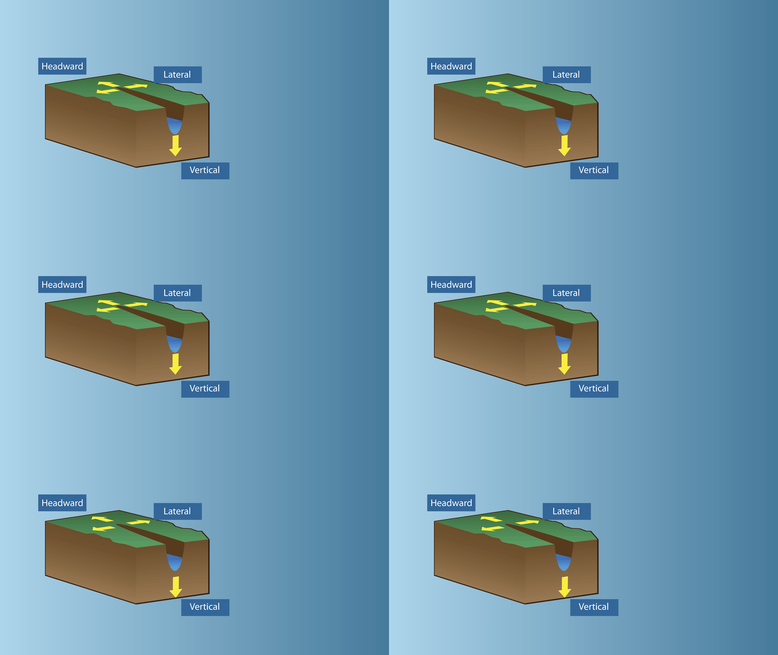
1. Headwards erosion it is a process by which a river increases its upstream length. This is achieved by a river cutting back at its source
2. Lateral erosion it is a process through which river channel is extended in its width due to sideways erosion at the outside banks of the rivers
3. Vertical erosion Vertical erosion takes place at the base of the river. The channel of the river gets deepened through vertical erosion Incorrect
Ans;- d) None of the above
Explanation;-
• All are incorrectly matched.
• River erosion takes place in three ways:-
1. Headwards erosion it is a process by which a river increases its upstream length. This is achieved by a river cutting back at its source
2. Lateral erosion it is a process through which river channel is extended in its width due to sideways erosion at the outside banks of the rivers
3. Vertical erosion Vertical erosion takes place at the base of the river. The channel of the river gets deepened through vertical erosion
- Question 8 of 10
8. Question
Which of the following landforms are found during Young stage of river?
1. V shaped Valley
2. Meander
3. Ox-bow LakeCorrectAns;- a) Only 1
Explanation;-
• Except V shaped valley, remaining 2 forms in Mature and Old age of rivers.
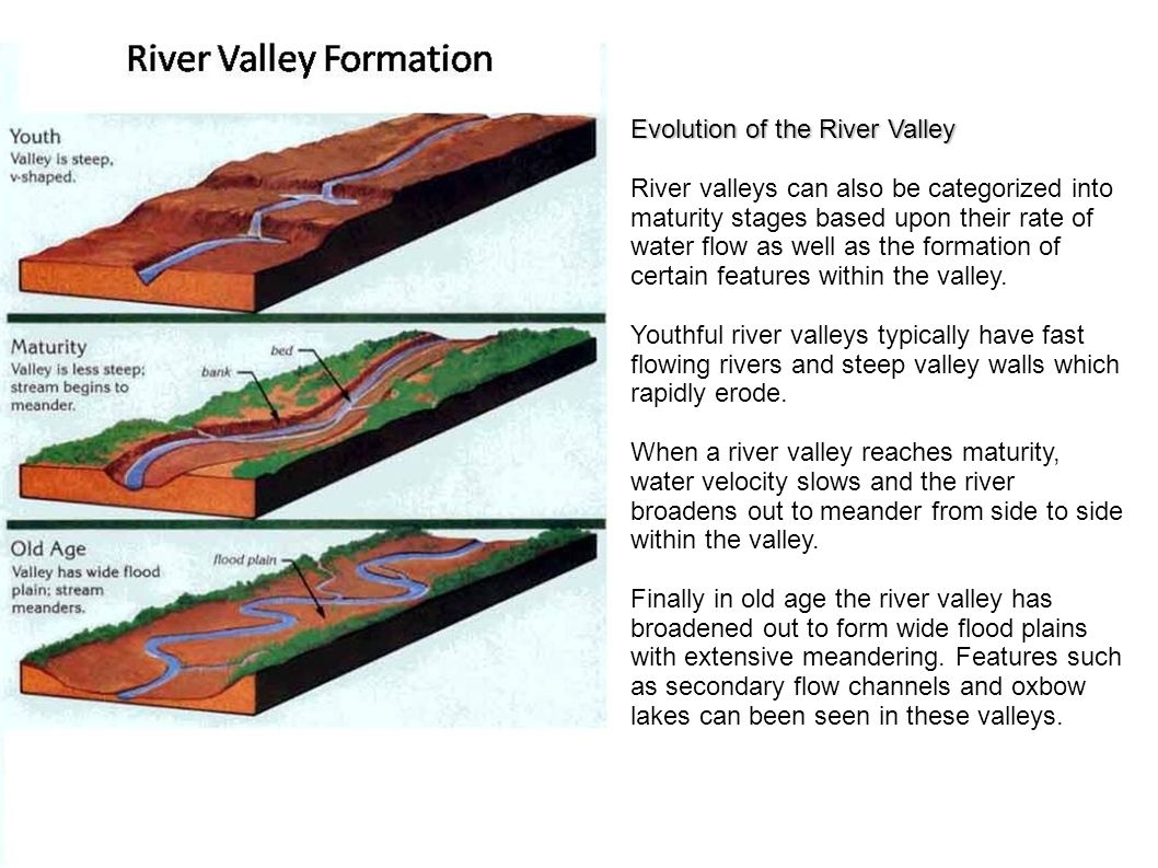
Youth
• Streams are few during this stage with poor integration and flow over original slopes
• The valley developed is thus deep, narrow and distinctly V-shaped with no floodplains or with very narrow floodplains.
• Downcutting predominates over lateral corrasion
• Streams divides are broad and flat with marshes, swamp and lakes.
• Some of the outstanding features which are developed in this stage are gorges, canyons waterfalls, rapids and river capture etc.Mature
• During this stage, streams are plenty with good integration.
• Lateral corrasion tends to replace vertical corrasion
• The valleys are still V-shaped but wide and deep due to an active erosion of the banks;
• Trunk streams are broad enough to have wider floodplains within which streams may flow in meanders confined within the valley.
• Swamps and marshes of youth stage, as well as flat and broad inter-stream areas, disappear. The stream divides turn sharp.
• Waterfalls and rapids disappear.
• Meander and slip off slopes are the characteristic features of this stageOld
• The river moving downstream across a broad level plain is heavy with sediments.
• Vertical corrasion almost ceases in this stage though lateral corrasion still goes on to erode its banks further
• Smaller tributaries during old age are few with gentle gradients.
• Streams meander freely over vast floodplains. Divides are broad and flat with lakes, swamps and marshes.
• Depositional features predominate in this stage
• Most of the landscape is at or slightly above sea level
• Characteristic features of this stage are floodplains, oxbow lakes, natural levees and Delta etc. Incorrect
Ans;- a) Only 1
Explanation;-
• Except V shaped valley, remaining 2 forms in Mature and Old age of rivers.
Youth
• Streams are few during this stage with poor integration and flow over original slopes
• The valley developed is thus deep, narrow and distinctly V-shaped with no floodplains or with very narrow floodplains.
• Downcutting predominates over lateral corrasion
• Streams divides are broad and flat with marshes, swamp and lakes.
• Some of the outstanding features which are developed in this stage are gorges, canyons waterfalls, rapids and river capture etc.Mature
• During this stage, streams are plenty with good integration.
• Lateral corrasion tends to replace vertical corrasion
• The valleys are still V-shaped but wide and deep due to an active erosion of the banks;
• Trunk streams are broad enough to have wider floodplains within which streams may flow in meanders confined within the valley.
• Swamps and marshes of youth stage, as well as flat and broad inter-stream areas, disappear. The stream divides turn sharp.
• Waterfalls and rapids disappear.
• Meander and slip off slopes are the characteristic features of this stageOld
• The river moving downstream across a broad level plain is heavy with sediments.
• Vertical corrasion almost ceases in this stage though lateral corrasion still goes on to erode its banks further
• Smaller tributaries during old age are few with gentle gradients.
• Streams meander freely over vast floodplains. Divides are broad and flat with lakes, swamps and marshes.
• Depositional features predominate in this stage
• Most of the landscape is at or slightly above sea level
• Characteristic features of this stage are floodplains, oxbow lakes, natural levees and Delta etc.
- Question 9 of 10
9. Question
Which of the statements are correctly matched regarding Waterfalls and Rapids?
1. Waterfalls = are stream sections with extremely strong currents, numerous obstacles, and steps in their streambeds.
2. Rapids = is a vertical drop in a streambed. Both are sites of vigorous erosion .CorrectAns;- d) None of the above
Explanation;-
• Both the statements are reversed and that’s y answer is D.
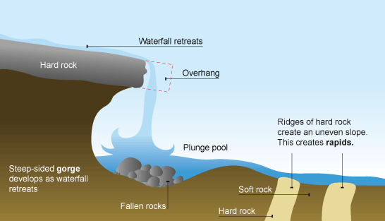
• Rapids are stream sections with extremely strong currents, numerous obstacles, and steps in their streambeds. A waterfall is a vertical drop in a streambed. Both are sites of vigorous erosion . Rapids often form where resistant bedrock confines a stream to a narrow channel, and forces an increase in water velocity.
 Incorrect
Ans;- d) None of the above
Explanation;-
• Both the statements are reversed and that’s y answer is D.
• Rapids are stream sections with extremely strong currents, numerous obstacles, and steps in their streambeds. A waterfall is a vertical drop in a streambed. Both are sites of vigorous erosion . Rapids often form where resistant bedrock confines a stream to a narrow channel, and forces an increase in water velocity.

- Question 10 of 10
10. Question
Which of the statements are correctly matched regarding Potholes and Plunge pool?
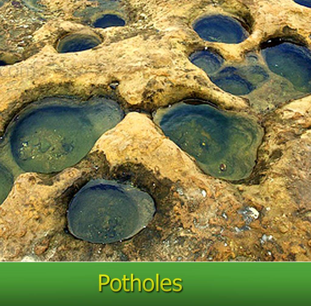
1. Potholes = are more or less circular depressions over the rocky beds of hills streams.
2. Plunge Pools = are nothing but large, deep potholes commonly found at the foot of a waterfall.CorrectAns;- c) Both 1 and 2
Explanation;-
• Both the staements are correctly matched.
• Potholes are more or less circular depressions over the rocky beds of hills streams. Once a small and shallow depression forms, pebbles and boulders get collected in those depressions and get rotated by flowing water.

• Plunge pools are nothing but large, deep potholes commonly found at the foot of a waterfall.
 Incorrect
Ans;- c) Both 1 and 2
Explanation;-
• Both the staements are correctly matched.
• Potholes are more or less circular depressions over the rocky beds of hills streams. Once a small and shallow depression forms, pebbles and boulders get collected in those depressions and get rotated by flowing water.

• Plunge pools are nothing but large, deep potholes commonly found at the foot of a waterfall.


